August 16
Camp Name
The Hidden Water
Camp Name (Spanish)
La Agua Escondida
Brightness of the Moon
5%
Distance Traveled
4 leagues / 10.5 miles
Daylight
13 hours / 37 minutes
Water Resources
La Agua Escondida = The Hidden Water
Journal Description for August 16th
On the 16th we discovered more than half of the horses missing, since, having had no water, they strayed away looking for it and found it near the trail halfway back on yesterday’s march. They made their appearance, arriving when it was already late. For this reason we left La Agua Tapada at half past ten in the morning, taking a little-used trail which we figured would last us until we again reached El Río de Dolores, which we intended to follow. However, after we had traveled over it for two leagues to the northwest and a league and a half west, it played out on us because the ground was very loose and it had been obliterated by the rains. From here we took to the northwest; at a quarter of a league we entered a canyon, wide at its mouth, where we found a well-used trail. We followed it and, after another quarter league of traveling northward, we found a water source that appeared to us sufficient for the people and the horse herds and which, for its lying hidden on the eastern side within a dense wood of piñon and juniper, we called La Agua Escondida.77“The Hidden Water.” No further directions are given because the trail goes right to it.
Two waterholes were made so that the horse herds could drink, and they drank all of it, although not quite enough to be sated altogether. While we were reconnoitering the terrain on either side in order to proceed this afternoon, Don Bernardo Miera set out all alone through the said canyon without our seeing him. And so, while impelled to continue the day’s march, we halted and sent another companion to bring him back before he could get lost; but he had gone so far ahead that they did not arrive until after midnight at the place where the rest of us were waiting, extremely worried over the two’s delay. They said that they had arrived through the canyon at El Río de Dolores, and that in the intervening space there was no more than a difficult but improvable stretch for getting through. This made us decide to continue through here the next day. Today four leagues.78Ten and one-half miles.
Scroll to the bottom to view photos.
Notable Event
“On [the morning of] the 16th we discovered more than half of the horses missing, since, having had no water, they strayed away looking for it and found it near the trail halfway back on yesterday’s march.”Miller Report Summary
During the day the expedition passed slightly east of present Dove Creek and (on August 16) west of Egnar to enter the upper reaches of Summit Canyon. The August 16 camp was located just about on the present Utah-Colorado boundary.DEEEP’s Field Notes
Copyright © 2024, DEEEP Colorado. All Rights Reserved.
August 16, 1776
By Cole Crocker-Bedford: DEEEP Team Member
Near the end of their travel day on August 16, 1776, the Domínguez-Escalante Expedition “entered a canyon, wide at its mouth, where we found a well-used trail. We followed it and, after another quarter of league of traveling northward, we found a water source that appeared to us sufficient for the people and the horse herds and which, for its lying hidden on the eastern side [of the canyon] within a dense wood of pinyon and juniper, we called La Agua Escondida” (The Hidden Water). The next day Domínguez and Escalante named the canyon El Laberinto de Miera (Miera’s Labyrinth) because of its features after it becomes deep with high cliffs farther to the north and northeast.
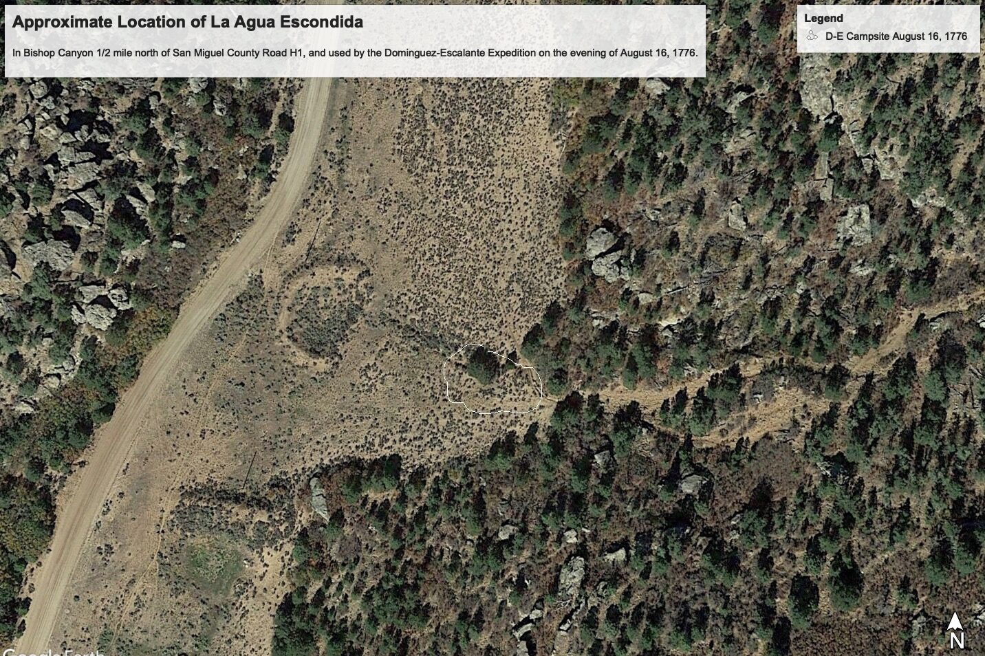
Today the southern six miles of El Laberinto de Miera is called Bishop Canyon. (In my essay about August 17, 1776, I will explain why I am positive that the southern six miles of El Laberinto de Miera is now called Bishop Canyon.) Because the Domínguez-Escalante Expedition was traveling toward the northwest when they entered it where it is “wide at its mouth”, and then found water on its east side one-quarter league (2/3 mile) down canyon to the north, I believe that the Domínguez-Escalante Expedition must have entered what is now called Bishop Canyon near the location of what is now the intersection of San Miguel County Road H1 and San Miguel County Road 5Hn. There the canyon’s valley is very broad and not steep, and one-half air-mile (about 2/3 winding trail mile = 1/4 league) north of San Miguel CR H1 a small side canyon enters Bishop Canyon from the east. One quarter mile up the steep side canyon is Bishop Canyon Spring. On the USGS Egnar Quadrangle, Bishop Canyon Spring is found just northwest of the center of section 9, T42N, R19W.
Escalante’s journal make no mention of pushing up a steep canyon east of the main canyon, so I believe that they found the water on the east side of the main canyon at the bottom of the usually dry creek that is supplemented by Bishop Canyon Spring. Today at that location is a 4-foot-deep hole, several feet long in the direction of water flow (E to W), that remains wet even when surface water is not coming down the side canyon that holds Bishop Canyon Spring. The water hole is surrounded by a very small patch of pinyon trees that were left standing within a general area that decades ago was converted to grass from the original P-J woodland. Escalante recorded: “Two waterholes were made so that the horse herds could drink, and they drank all of it, although not quite enough to be sated altogether.” The latitude of today’s small water hole in the center of the small patch of pinyon pines is 37 degrees, 54’, 58.7” North, and its longitude is 108 degrees, 58’, 23.3” West. Its elevation is 7,023 feet.
My Google Earth photo titled Approximate Location of the La Agua Escondida Campsite shows the small patch of pinyons in which the water hole lies, within a white line labeled D-E Campsite August 16, 1776. Since I created that Google Earth file, I have come to believe that the actual sleeping area of the men of the Domínguez-Escalante Expedition was likely a hundred feet farther west where the ground is flatter.
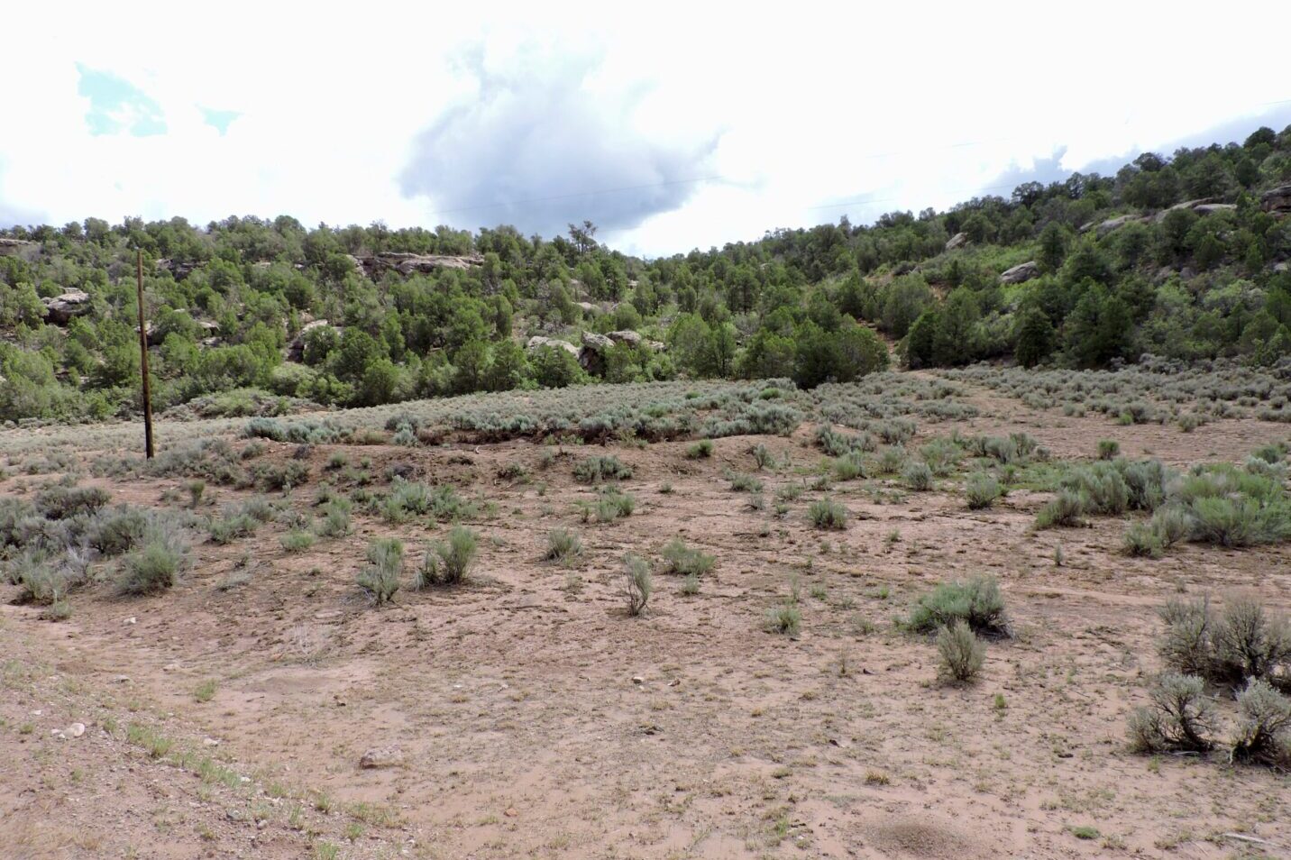
The entire area is private land but can be viewed from San Miguel County Road 5Hn. An earthen stock pond now exists 100 feet WNW of the small water hole that likely had been La Agua Escondida. The earthen stock pond is empty in the Google Earth photo but contained water during the three times that I visited the site. On July 31, 2022, I took the enclosed photo while standing on County Road 5Hn looking due east over the campsite of August 16, 1776. In the middle of the photo one can see the earthen berm of the modern stock pond but cannot see the water that it held the day of the photo. Behind the right side of the berm — about one-third of the way from the right side of the photo — is the very small patch of pinyon pines that surrounded the wet hole that I believe was Domínguez-Escalante’s La Aqua Escondida (The Hidden Water). That small patch of pinyon pines is about 70 feet closer to the camera than the edge of the large stand of P-J behind the small patch.


