Home
DEEEP’s Research
DEEEP’s Research
Anecdotes, Stories and Articles that provide additional information about this journey
You cannot copy content of this page
Fray Francisco Atanasio Domínguez, born in around 1740 in Mexico City, New Spain (modern-day Mexico), was a remarkable Franciscan friar, explorer, and missionary whose contributions to the exploration and documentation of the American Southwest during the late 18th century remain integral to our understanding of this region’s history. His extraordinary life and accomplishments, often undertaken under difficult circumstances, have left an indelible mark on the history of the American Southwest. He served as the official leader of the Domínguez-Escalante Expedition, entrusted with the responsibilities of exploring uncharted territory on behalf of both the Franciscan Order and the governor, who represented the king.
Historically, the credit for this expedition has been mistakenly attributed to Father Vélez de Escalante. For decades, American historiography erroneously referred to it as the Escalante expedition. Even today, there are more places along the trail bearing Escalante’s name than Domínguez’s. This misconception stemmed from the fact that Father Escalante penned the diary in his own hand, leading some to believe he was the mastermind. However, a thorough examination of the diary, combined with knowledge from Domínguez’s other writings, offers a different perspective.
The diary, primarily authored by the young Escalante in his role as a clerk, consistently reflects Domínguez’s involvement in decision-making. It frequently employs the collective “we,” representing the consensus of the two fathers. Notably, Domínguez’s name precedes Escalante’s in the journal, a clear indicator of his authority.
Father Domínguez’s distinct personality emerges from the numerous letters and reports he composed. He possessed a strong sense of responsibility and hierarchy, demonstrating a penchant for meticulous attention to detail—some have even referred to him as a perfectionist. Given these traits, it’s unlikely that Domínguez delegated the crucial task of writing the expedition report entirely. Undoubtedly, he supervised the narrative and was, at the very least, a co-author of the opinions and judgments expressed within it.
Born in Mexico City around 1740 to Lucas Domínguez, a merchant, and Juana Francisca Etchegaray, Father Domínguez hailed from a family with roots in Spain that had settled in New Spain decades earlier. In 1753, he entered the Franciscan Recollects of San Cosme convent in Mexico City. This education would later prove invaluable in his exploratory endeavors.
Over the next two decades, little is known about Domínguez’s life, but it is reasonable to assume he ascended to positions of responsibility within the order. In 1772, he was listed as the commissioner of the Third Order in the Convent of Veracruz, Mexico, indicating his growing prominence.
By 1775, Domínguez had earned a reputation within the order for his intelligence, work ethic, and discipline. Consequently, he was entrusted with the task of assessing a province, receiving specific instructions to provide a detailed report on mission status, geographical locations, building conditions, economic situations, languages spoken by indigenous populations, and more. He was also tasked with cataloging the possessions of the missions and their missionaries, documenting their doctrinal work, and the spiritual progress of settlers and indigenous people.
Furthermore, Domínguez was assigned the intricate task of exploring the possibility of establishing new routes connecting scattered missions along the northern border of the empire.
This mission demanded expertise not only in religious matters but also in geography, ethnography, and politics—a testament to the multifaceted role of missionaries, serving both their order and the interests of the King of Spain and the Empire.
Driven by determination, Domínguez embarked on a journey from Mexico City to El Paso del Río del Norte, arriving in September 1775. The arduous trip took approximately three months, as it relied on commercial caravans. Domínguez spent a few months in El Paso before continuing his journey to Santa Fe in early 1776, joining another caravan.
Throughout 1776, Father Domínguez simultaneously worked on two interconnected projects: documenting the missions and seeking a route to Monterrey. In April and May of that year, he meticulously visited nearly all 22 missions within a 300-kilometer radius of New Mexico. Each visit lasted approximately three days, and he concluded each with a detailed report. These missions varied widely in their conditions, from well-operated ones to abandoned and priestless establishments.
During his travels, Domínguez received word of Father Vélez de Escalante, a young, active missionary stationed at the remote mission of Zuñi, who had been independently investigating the route to Monterrey for a year. Encouraged by this discovery, Domínguez invited Escalante to meet in Santa Fe.
Upon meeting Father Escalante, Domínguez wasted no time in forging an alliance, pooling their efforts to propose an exploratory expedition to the governor. Domínguez described this partnership and the genesis of their project in a letter to the Provincial Minister, highlighting their shared enthusiasm and the governor’s supportive response.
This collaboration enabled Domínguez to achieve two objectives: complete his exploration trip and revisit some missions he hadn’t seen earlier when returning to Santa Fe from the West. In December 1776, he composed a report on these previously unvisited missions. Thus, the Domínguez-Escalante Exploration diary and the report on the missions complement each other, with the former detailing the geography and lifestyles of indigenous people in remote territories, while the latter provides insights into the situation in the settled New Spanish territory.
It may appear peculiar to modern readers that the early and late entries in the expedition diary are brief notes on distances and anecdotes. This brevity results from the fact that these explorers traversed terrain near Santa Fe, the province’s political and religious center, which required no detailed explanations. Moreover, Father Domínguez provided more comprehensive descriptions of these places in his report.
Father Domínguez’s most significant contribution to New Mexico’s history lies in the diary of the 1776 expedition and his report on the missions. Following the presentation of these documents, he resumed his administrative duties as custodian in Santa Fe.
Father Silvestre Vélez de Escalante, a name often overshadowed by the
more prominent figures of Spanish exploration and missionary work in the
American Southwest, was nonetheless a remarkable individual whose contributions to history cannot be understated. He was born in the quaint town of Treceño, nestled in the picturesque region of La Montaña, which is now part of Cantabria, Spain, on June 1, 1749.
The motivations behind Vélez de Escalante’s journey to the Americas remain
shrouded in history. However, it is safe to assume that, like countless others
from his region and across Spain during the 18th century, he was drawn to
the Americas by the allure of adventure and extraordinary experiences.
Though his family possessed noble lineage, they lived humbly, with meager
resources. Given their limited holdings, it is hardly surprising that Silvestre
Vélez de Escalante cast his gaze beyond his native valley in search of a brighter future.
Regrettably, there exists no documentation specifying the exact moment of
Escalante’s arrival in the Americas. Nevertheless, by 1767, just having turned eighteen, he had joined the novitiate at the San Francisco convent in Mexico City. By 1774, he was already recognized as a priest. Despite his youth, Escalante stood out among his peers within the clergy. His talents, erudition, dedication to arduous tasks, and, most importantly, his virtuous character, all contributed to his swift ascent within the clergy.
Undoubtedly, Escalante commanded the respect and admiration of his fellow
order members. It’s worth noting that during his time, Father Escalante went
by the name Father Vélez; it was only later, for various reasons, that the name Escalante became predominant, a nomenclature we shall maintain for consistency with historical tradition.
Escalante embarked on his journey to New Mexico with a clear objective: to meticulously assess the frontier’s situation. Who were the friendly and hostile tribes? Where were they located? What were the activities of the military forces? Could a route be established to the recently established mission of Monterrey? If so, what path would it follow? The most direct route to Monterrey passed through Moqui territory, but all New Mexican missionaries were well aware that the Moqui Indians had not welcomed missionaries into their midst since 1680. Would they encounter resistance from the Moqui Indians if they attempted to cross their territory?
Escalante proceeded to the remote Zuni mission, a place that had been sorely neglected for years. It was even used as a place of confinement for convicts, tasked with defending the mission from potential attacks. Father Damián Martín, who had served there for years and left dissatisfied and weary, briefly accompanied Escalante before leaving him to his solitary assignment. Father Escalante’s mission in Zuni was named Our Lady of Guadalupe.
Escalante was fortunate to encounter Don Bernardo de Miera y Pacheco, a resident of Santa Fe, who shared his Cantabrian roots and a burning desire to fulfill the viceroy’s wishes. Although they had arrived in America at different times, their meeting was destined to be fruitful. When Escalante arrived in New Mexico towards the end of 1774, Miera was already sixty-one, firmly established, and responsible for a family. Their initial encounter is documented in a letter Escalante sent from the Zuni mission to his superior, where he mentioned meeting a fellow countryman, Don Bernardo Miera. The experienced Miera, a veteran soldier-colonist, shared tales of his various expeditions and encounters with bearded Indians, igniting Escalante’s curiosity and a fervent desire to meet this lost tribe rumored to be descendants of Spanish explorers.
Following his meeting with Miera, Escalante boldly led his first expedition into the feared and respected Moqui (Hopi) region, a journey that lasted just over a week. This initial expedition served as a test of his mettle and a rehearsal for a more extended and perilous adventure.
In 1776, Father Vélez de Escalante embarked on a journey of epic proportions. Alongside Francisco Atanasio Domínguez, another Franciscan priest, he led an expedition to explore the uncharted territories of what is now the American Southwest. This journey would take them through the vast and daunting expanse of the Colorado Plateau, a region fraught with peril and unknown dangers.
Their expedition was not solely driven by a desire for geographical discovery.
Father Vélez de Escalante and Father Domínguez were on a dual mission: to explore new lands and, in doing so, establish connections with native peoples and bring Christianity to them. They believed that by forging relationships with the indigenous inhabitants of these regions, they could both fulfill their spiritual mission and further the interests of Spain in the New World.
For a more comprehensive understanding of Escalante’s character, one can peruse other documents authored by him. For instance, in a letter penned in 1777 to his fellow Franciscan brothers, he urged them to adhere more closely to the tenets of San Francisco, particularly regarding the vows of poverty and chastity. The letter hints at a perceived decline in the moral fiber of some Franciscans, a situation Escalante found lamentable. According to Rick Hendricks, the official historian of the State of New Mexico, the tone and content of Escalante’s letter reflect the character of a “strict and idealistic young man.” Alonso del Val, a fellow member of the order, hailed him as “courageous, dedicated, and, in a word, heroic.”
It is reasonable to assume that the Pueblo Indians residing with him in the
Zuni mission held him in high regard. Escalante’s letters make no mention of rebellion or resistance within the mission, despite past occurrences. On the
contrary, he repeatedly wrote about how the Zuni Indians who accompanied him during the Moqui expedition watched over his safety and alerted him to potential threats from other Indian groups and potential dangers. Regrettably, we lack the testimonies of these Zuni Indians.
Tragically, Escalante’s life was cut short at the young age of 31. His passing occurred in El Parral, a town now located in northern Mexico, in April 1780, as he was en route to Mexico City in search of medical treatment. The cause
of his death is believed to have been prostate or bladder cancer.
Today, Father Silvestre Vélez de Escalante’s legacy lives on in the records of his courageous journey and in the enduring impact of his missionary work.
He stands as a symbol of the early Spanish explorers who ventured into the unknown, driven by a blend of faith, curiosity, and a deep sense of duty.
In the late 1770s, Spain was very eager to find an overland route to the Californias, which were sparsely settled. Captain Juan Bautista de Anza the Younger, of the presidio of Tubac, in Arizona, succeeded in 1774 by finding a route from Altar, Sonora, across the Camino del Diablo to Yuma Crossing on the Colorado River, which was controlled by Quechan (Yuma) Indians, and on to Mission San Gabriel and Monterey. He was accompanied on this exploratory journey by the Franciscan missionary Fray Francisco Garcés. A year later he returned to California with 240 settlers by following the Santa Cruz River north and the Gila River west and forded the Colorado with the help of the Quechans, finally founding the city of San Francisco in 1776.
Fray Garcés was the Father Minister at Mission San Xavier del Bac near Tucson. He was known for his energy and zeal. His sympathy and curiosity about the Indians was so great that a colleague remarked that he was almost an Indian himself. He and Fray Silvestre Vélez de Escalante undertook an exploratory reconnaissance of a northern route to California from Santa Fe in 1775. Escalante was younger than Garcés and much less sympathetic to the Indians and their customs. The Hopi leaders in Orayvi told Escalante that they were not interested in “renouncing their apostasy” and becoming Christian and did not want to have any Spaniards settle on their lands. Escalante was also very shocked at some of their dancing, dress, and ceremonies. For this reason, when the Domínguez-Escalante Expedition in 1776 tried again to find a route, they circled north through Colorado and Utah. Their attempt was unsuccessful, and they had to circle back to Santa Fe by going through the Hopi villages, which were even more unfriendly than before. The Hopi fed the travelers, but refused to speak with them and indicated to them that they were to move on immediately and not stay any longer than necessary. The Domínguez-Escalante Expedition went through what is now Arizona from October 15 through November 24,1776.
An account of Escalante’s 1775 reconnaissance to Hopi (or “Moqui,” as they were known to the Spanish), as well as a translation of Fray Garcés’s diary of a visit there in July, 1776, can be found in Moquis and Kastiilam: Hopis, Spaniards, and the Trauma of History, Volume II, 1680-1781, edited by Thomas E. Sheridan, Steward B. Koyiyumptewa, Anton Daughters, Dale S. Brenneman, T.J. Ferguson, Leigh Kuwanwisiwma, and Lee Wayne Lomayestewa. In this diary, Garcés reports writing a letter to the missionary in Zuni, telling him to warn Escalante and Domínguez of the opposition and hostility of the Hopi.
The southern route charted by de Anza was therefore considered the only practical route. However, in 1781 the Quechans rebelled and killed many Spanish, including Fray Garcés. Fray Vélez de Escalante had died in 1780 of a long illness, before he turned thirty.
Don Bernardo Miera y Pacheco, originally of Santibáñez in the province of Santander, Spain, contributed various forms of artwork to the historic churches of the Archdiocese of Santa Fe. Scholars and New Mexico Historians have denoted the various trade works of Miera y Pacheco who served as cartographer on various expeditions with Spanish explorers and artistic craftsman who contributed to the artistic New Mexico santero style of religious images adorning the historic churches of New Mexico.
Miera y Pacheco left his native Spain and resided in Mexico and El Paso del Norte. He was approached by Governor Francisco Antonio Marín del Valle to become an alcalde mayor (mayor) for the Galisteo and Pecos districts in New Mexico. However, this was one of many opportunities for Miera y Pacheco who was utilized by Spanish explorers as official cartographer on various expeditions.
Although the various maps generated by Miera y Pacheco displayed vast new
lands of Spanish exploration with pictorial depictions of Native Americans found along the way, these maps provided what could be the beginning of what we refer to today as ethnography, depicting detailed artistic sketches of Native American tribes encountered during various expeditions. “All his maps for Marín del Valle featured vignettes: leaping buffalos, Hopi girls, armed Comanches, a battle between Faraón Apaches and Spaniards, and even the pope in his chariot hitched to the lions of Castile.” 1“Mas Allá: Bernardo de Miera y Pacheco and the Eighteenth-Century Kingdom of New Mexico”, Kessell, John L. New Mexico Historical Review, Article 2, Volume 88, Number 2, Spring 2013 Just as Miera y Pacheco displayed the new kingdom of New Mexico to Governor Francisco Antonio Marín del Valle with his maps while serving as cartographer, it was Governor Marín del Valles and his wife Maria Ignacia Martinez de Ugarte who requested the artistic talents of Miera y Pacheco for assistance with a new chapel.
Marín del Valle and his wife were instrumental in allocating the funding and
building the La Castrense Military Chapel. Due to Marín del Valle and his wife’s devotion to Nuestra Señora de la Luz (Our Lady of Light), the military chapel was named in honor of the Marian Image. Miera y Pacheco was tasked with the project to construct a reredos (altar screen) for La Castrense. “At the far end of its dim one-hundred-foot-long nave stood an unexpected three-tiered gallery of saints in bas relief. Roughly nineteen feet wide and twenty-five feet tall, built of fitted, carved, and brightly painted white stone blocks, it was the unsigned work of Miera, sculptor and painter.” 2“Mas Allá: Bernardo de Miera y Pacheco and the Eighteenth-Century Kingdom of New Mexico”, Kessell, John L. New Mexico Historical Review, Article 2, Volume 88, Number 2, Spring 2013 The stone reredos was one of the many creations of artwork Miera y Pacheco created currently housed in historic churches of the Archdiocese of Santa Fe.
Miera y Pacheco’s magnificent stone reredos was constructed of local white stone quarried north of Santa Fe in the area known today as Nambe. Various religious images are depicted in the stone reredos; however, Miera y Pacheco incorporated saints pertaining to both the Jesuit and Franciscan orders. The incorporation of Jesuit saints San Juan Nepomuceno (St. John Nepomuk), and San Ignacio (St. Ignatius) were due to Governor Marín del Valle’s upbringing with the Jesuit order, which he was very fond of. Although the Spanish missionaries in the area were Franciscans, Miera y Pacheco depicted saints who reflected admiration and devotion particular to Governor Marín del Valle who commissioned the work.
On June 3, 1760, La Castrense military chapel was officially founded by Governor Marín del Valle and officially blessed on May 23, 1761 by Vicar Don Santiago Roybal in the presence of Rev. Custos Fray Jacobo de Castro, Vice Custos Fray Manuel Zambrano, as well as other dignitaries. The stone reredos graced the military chapel from ca. 1759 to ca. 1851. Due to the decline in usage by military families and the chapel being primarily located in midst of the noisy end of the Santa Fe Trail, newly elected Bishop John Baptist Lamy of the Vicariate Apostolic of New Mexico, decided to sell the property and relocate the stone reredos to the parroquia (parish church).
Meanwhile the Vicariate Apostolic of New Mexico underwent two significant
changes: with the elevation to the status of Diocese and Archdiocese. On July 29, 1853 Pope Pius IX established the Diocese of Santa Fe, 3Collecti ons of the Archdiocese of Santa Fe, AASF 1853 #12 and on February 12, 1875, Pope Pius IX elevated the Diocese to the Archdiocese of Santa Fe naming Jean Baptist Lamy first Archbishop of the Archdiocese of Santa Fe.04Collections of the Archdiocese of Santa Fe, AASF 1875 #12
The elevation by the Holy See to the status of Archdiocese led to many changes and Archbishop Lamy wanted to construct an elaborate cathedral similar to his homeland, France, because he felt the parroquia was in need of repairs. For many years the stone reredos was housed in storage at the main parroquia, which later was demolished upon the building of what is now the Cathedral Basilica of St. Francis of Assisi (Cathedral). In 1894, the stone reredos became the first exhibit displayed in the first Archdiocesan museum at the Cathedral parish and remained until 1940.
On April 6, 1939, Archbishop Rudolph Aloysius Gerken formally announced
the establishment of a new parish in Santa Fe to be named Cristo Rey; with plans to move the stone reredos from the Cathedral and utilize the stone reredos as the main focal point of the new parish. Official groundbreaking for the new parish occurred on April 26, 1939. The new parish was constructed of traditional adobe (mud and straw formed bricks). Archbishop Gerken formed the first adobes for the new church, and architect John Gaw Meem began to construct the new parish. Utilizing the assistance of parishioners, adobe bricks were created by the people of the parish to construct the new church. The first mass was celebrated on January 1, 1940. Although parishioners are aware the stone reredos is from the La Castrense military chapel, many forget the artist behind the magnificent 18th century altar screen.
Miera y Pacheco is not as world renowned as he should be for his contributions to cartography and providing the leading templates for maps of the vast lands of the southwest and New Mexico. However, his artwork has also been a quiet treasure for parishioners of the various churches in the Archdiocese of Santa Fe. The magnificent stone reredos remains the most magnificent artwork depicting colonial New Mexico in the 18th Century and the artwork of Miera y Pacheco on permanent display at the parish of Cristo Rey.
The stone reredos has been linked as a contributing resource to what is now known as the santero art form in New Mexico and utilized by traditional santero artists to this day. As with his cartography displaying ethnographic details, the images of religious icons were detailed to perfection in Miera y Pacheco’s artwork and specifically the stone reredos. Miera y Pacheco created an influential piece. The stone reredos is the sole piece of 18th century artwork of its kind in New Mexico. Although santeros have mimicked the artwork of Miera y Pacheco creating santos and wooden reredos, none have ventured to create stone reredoses.
Andrés Muñiz
Andrés Muñiz was from Bernalillo, New Mexico. He served as a guide for the Domínguez-Escalante Expedition because he had valuable previous experience.
Andrés had participated in at least one of the two expeditions that explorer Juan María de Rivera had carried out a decade earlier, in 1765, reaching near the current town of Moab, Utah. He had also participated in an expedition that returned to that area in 1775, with Pedro Mora and Gregorio Sandoval. In other words, Andrés had already completed the first section of the route, the section that the Domínguez-Escalante expedition covered during the month of August 1776. This gave him an advantage over the rest of the expedition members. Another added advantage was that Andrés knew the Yuta language and served as an interpreter, a fundamental role in this type of company. For all these reasons, Andrés plays a leading role in the text. He is present, in his capacity as an interpreter, in the meetings with the different groups of Indians, and his good work is essential for the success of the company. Andrés is also a valuable and experienced explorer, it is he, on many occasions, who is in charge of finding the path to follow in difficult situations. Andrés is a man raised on the border, used to making a living and negotiating with different groups of Indians and Spaniards, in different languages. He knows the Spanish well, the missionaries. His work in the expedition is paramount and of as much value, or more, than that of the leaders. The expedition members depended
on the generosity of the groups of Indians they found in their path and the instructions they were given. Andrés was, in many cases, the representative of the group.
Antonio Lucrecio Muñiz
He was the brother of Andrés and a citizen of Embudo, a town north of Santa Fe.
Lucrecio usually appears in the text accompanying his brother, without contributing
anything in particular. He helps his brother both in scouting and in the mess of trying to trade with the local Indians.
Morley Ballantine, matriarch of the family that publishes the Durango Herald, once
characterized Robert Delaney as someone “who looked a bit like a leprechaun . . . an Irishman who had a gift for blarney and storytelling.”
Ballantine, along with most who knew him, also remembered him as a scholar, historian, author, revered college professor, community activist, and iconic founding director of Fort Lewis College’s Center of Southwest Studies. He was a major influence in my life, an important catalyst in my transformation from college math major to a student of history and southwest studies. Southwest history and culture remain my passions to this day.
Robert W. Delaney was born on October 15, 1918 in Macon County, Missouri, where his father was a machinist for the Santa Fe Railroad and later a farmer. Delaney earned undergraduate degrees in education and history from Northeast Missouri State Teachers College.
During World War II, he served in the U.S. Army Air Corps as a navigation instructor. In 1951, during the Korean conflict, he worked in the U.S. Air Force’s Information and Education section.
In the meantime, Delaney had received his master’s degree in Inter-American Affairs in 1950, and earned his Ph.D. in history from the University of New Mexico in 1955. He joined Durango’s Fort Lewis College faculty in 1957 and was named full professor in 1962. With seed funding from Arthur and Morley Ballantine, Delaney helped establish Fort Lewis’s Center of Southwest Studies in 1964 and became its first part-time director. He became the full-time director in 1970.
During his nearly 30-year career at Fort Lewis, Delaney held several faculty and
administrative positions, including chair of the humanities division, acting director of the School of Arts & Sciences, and the college’s first Affirmative Action director. He was also very involved in the Durango community and received the Chamber of Commerce’s Outstanding Man of Achievement Award in 1969.
In 1975, after I had completed the course work for my Master’s degree in History at the University of Utah, Dr. Delaney and I were selected as one of seven teams of scholars to investigate the route of the 1776 Domínguez-Escalante Expedition as part of our nation’s Bicentennial. Delaney was the seasoned historian, I the wide-eyed, idealistic graduate student.
When Dr. Delaney and I began mapping out a plan for investigating our section of the Domínguez -Escalante route, I was excited about the prospect of examining portions of the trail on foot and even on horseback for parts of the route that traversed the Uncompahgre Plateau.
Reality soon set in, however, as we had only five days to cover the long distance between Carracas, Colorado and Montrose, Colorado. Following the route by auto was the only option. I’ll never forget when Dr. Delaney handed me an old twin-lens camera for use in taking photos. He made it clear that he had no idea how the thing worked and left it to me to figure out.
While I had used simple Kodak “point and shoot” cameras, operation of that old camera was as strange to me as it was to him. Somehow, I managed to get the photos that we needed. We used Bolton’s Pageant in the Wilderness as a guide, factoring in such things as the length of a league (as known in late 18th century Spanish colonial times) and the deviation of magnetic north to true north as it might have been in 1776. As we worked out our ideas, I took notes. Dr. Delaney then used the notes from each day to write the reports we submitted to Dr. David Miller, the project director at the University of Utah. Dr. Miller, coincidentally, was the chairman of my graduate committee, and we had developed a good rapport during my time as a student and teaching assistant.
Dr. Delaney was so highly regarded both at Fort Lewis and in the Durango community, I was always a little in awe of him. In the years after we worked on the Domínguez -Escalante project, I helped found the La Plata County Historical Society’s Animas Museum. I became its first director, and enjoyed a career there that lasted 33 years. In 1986, ten years after Colorado’s Centennial-Bicentennial year, Dr. Delaney retired from Fort Lewis. He and his wife, Maria (known affectionately as “Ria”) moved to Old Town in Albuquerque.
Delaney passed away on November 10, 2000 from cancer. I was surprised when Ria called to ask if I would be a pall bearer at his funeral. Honored and humbled as I was by her request, I had vacation plans that couldn’t be changed and had to decline.
Looking back on my own long career as a historian, museum director, author, historic preservation activist, and lover of all things Southwest, I realized what an important influence Dr. Delaney had been in my life. Faculty and students at Fort Lewis will know his name from the Delaney Library at the Center of Southwest Studies. I will always remember him as a mentor and friend.
Professor David E. Miller was an historian’s historian and recognized by most as the Dean of Utah’s historians in the twentieth century. As such, he was a natural choice to co-chair the 1976 Utah Bicentennial Domínguez and Escalante grant application and project. His long career as a professor of history at the University of Utah and his expertise on the Great Salt Lake, the history of the West’s fur trade and the major and minor trails across Utah and the Great Basin prepared him to tackle a project encompassing the scope of the 1776 journey of the Domínguez-Escalante party. His co-chairing the project meant the very best of the knowledgeable scholars in Utah and the surrounding region would respond to his request to join one of the seven teams and hit the research trail with energy and determination.
Dr. Miller was recognized for his long commitment and firm belief that informing
the citizenry of Utah was an integral part of his teaching responsibility. In the 1960s he pioneered the teaching of history using television. Sponsored by the University of Utah’s early version of its national PBS Utah television station, his history of Utah was presented and re-run for decades. Part of his presentation was an in-depth examination of the Domínguez-Escalante Expedition, highlighted by full use of photographs showing actual portions of the trail and detailed maps and geographical descriptions to help his audience understand the challenges facing the two Franciscan priests and their party.
Miller was well known and recognized for his contributions to the Utah Historical Society (now Utah State History) and its publication, Utah Historical Quarterly.
He was the author of numerous books, articles and book reviews and reports on
all aspects of Utah. He received numerous awards for his book and article
publications. His 1962 book on the Utah San Juan Mission effort and establishment of Bluff, Utah, entitled HOLE-in-the ROCK: AN EPIC IN THE COLONIZATION OF THE GREAT AMERICAN WEST, was his most awarded publication. For his long and in-depth research, writings and committee work, from very early in his career to his death, on all aspects of the Great Salt Lake, Miller was honored with the Utah State Place Names Committee designation of a portion of land on the Great Salt Lake’s Fremont Island as “David E. Miller Point.”
I knew Professor Miller for the last decade of his life. He was chairperson of the
Department of History and supported my entrance into the History Department
for graduate studies in 1967. He mentored me throughout that experience and became my boss when he was named director of the American West Center in
1973. He invited me to join him and Dr. Floyd A. O’Neil to conduct the on-ground
survey of Peter Skene Ogden’s expedition into the Snake country prior to his
publishing PETER SKENE OGDEN’S SNAKE COUNTRY JOURNALS, 1827-29 as part
of the Hudson’s Bay Record Society series. This experience was an important
career-shaping experience for me. It helped train me for participation in the Bicentennial 1976 Domínguez and Escalante project. I was extremely fortunate to be able to watch the master trail historian at work on site and to witness the thorough and exacting effort he built into his geographical research efforts.
Professor David E. Miller died on Monday, August 21, 1978, shortly after finishing his role in the Bicentennial Domínguez and Escalante project. His death was sudden and unexpected, leaving the Utah historians’ community with a very large hole to replace. Some, me included, would say that Dr. Miller and his legacy has yet to be equaled.
Sources
Ted J Warner, my dad, experienced life by immersion. Thankfully, he always took our family along.
Dad’s love of the American Southwest was sparked while studying for his bachelor’s degree at the University of California Berkeley in 1949. He was in the Bancroft Library trying to think of an individual to report on for a history class. He decided on historian Herbert E. Bolton because he knew Bolton had helped make the Bancroft Library a preeminent research center.
Bolton is best known for developing a “hemispheric theory” that the Spanish Borderlands are a construct of Spain’s intersection with all of the Americas. Clearly, Dad was impressed by Bolton as he affirms in his memoirs:
As a result of this exposure to Bolton, “The Dean of Borderland’s
Historians,” I determined to become a Spanish Borderlander.
He chose to earn a PhD in history at the University of New Mexico in Albuquerque because one of the history professors there was an acolyte of Bolton’s. The professor, according to my dad:
…was not a “two-by-four” historian, that is, one who is confined between the two book covers and within the four walls of the classroom, but one who gets out in the field and retraces old Spanish trails using journals of explorers, missionaries, and soldiers, as his sources. I had no idea I would one day be in that same position but eventually it happened.
One of Dad’s favorite places in New Mexico was El Morro (aka Inscription Rock). When arriving at particular epigraph, my dad always paused to admire it. (Although it’s possible he really just needed to catch his breath from the hike!) It was etched into the stone by Don Felix Martinez de Torrelaguana in 1636. A standard used by many Spanish explorers, it proclaims simply, “Pasamos por Aqui.” Dad’s dissertation is on this man. Some of his research was conducted in the Coronado Room at UNM where some original documents are located. But he wanted to work from additional primary sources, so he took the family with him to Mexico City to search in the Archivo General de Mexico.
The great problem I had was with paleography, the translation of ancient
documents. I had no guidelines and everything I read on Martinez was in
17th and 18th century handwritten documents: campaign journals, letters,
reports, trials, etc. I took one solid year to simply learn how to handle these documentos.
In 1963, our family moved to Provo, Utah and he began his 30-year teaching career at Brigham Young University. It’s unclear what caught my dad’s attention about the Francisco Atanacio Domínguez and Silvestre Vélez de Escalante expedition on the Old Spanish Trail. But the subject set the course for the rest of his professional, public, and personal life.
In the Forward written by my dad as the editor of The Domínguez-Escalante Journal, it says:
…as a way to commemorate the two-hundredth anniversary of the
expedition during this bicentennial year of the United States, a new and definitive translation was appropriate in order to correct the numerous
errors and false assumptions which have developed concerning it over
the last half-century and more.
This meant accessing the actual Domínguez–Escalante journal to use as the primary source. Only early copies of the original journal survive and one is housed in the Archivo General de Indias in Seville, Spain. It’s dated July 26, 1777, six months after Frays Domínguez and Escalante returned from the expedition. My dad was the natural choice to perform that work because of his expertise with paleography.
Dad took a sabbatical leave from teaching in 1968 and our family went to Spain for a year. The transcription complete, it was translated by Angelica Chavez and published in 1976 as, The Domínguez-Escalante Journal: Their Expedition Through Colorado, Utah, Arizona, and New Mexico in 1776.
After the book came out, Dad became a popular speaker at functions before various civic groups, clubs, and societies. After my mother recreated the robes of an authentic Franciscan priest accessorized with rope ties and a hand-carved, rustic wood crucifix, Dad presented portions of the journal as Father Domínguez. A video of one of these programs is available on YouTube: https://youtu.be/669WeEgqEbM
Growing up, when my friends’ families vacationed in Southern California they went to the beach and Disneyland. We toured missions and old churches. We found this dreary as children and downright unbearable as teenagers so we registered our disappointment often and emphatically. As Dad predicted, and is universally a given, I’m now sad I didn’t pay attention and learn. (Note: we also saw more than our share of ancient pueblos in the Southwest which allowed my dad to repeat this self-coined phrase: “We went to see the ruins and we became one of them!”)
My dad found a passion for the Spanish Borderlands as a 20-year-old undergraduate student. He sustained and shared that passion until he died at age 85 in 2014. On El Morro, the Spanish explorer’s inscription announces, “We Passed By Here.” As per his wishes, Dad’s epitaph reads, “Paso Por Aqui.”
Sources
Warner, Ted J. The Secret and Not-So-Secret But Still Expurgated Memoirs of Ted J. Warner, Vol. 1. Self-published, 1998.
Domínguez, Francisco Atanacio and Vélez de Escalante, Silvestre The Domíinguez-Escalante Journal: Their Expedition Through Colorado, Utah, Arizona, and New Mexico in 1776. Fray Chavez, Angelico, translated by. Warner, Ted J., edited by. Brigham Young University Press, 1976.
Born in Ogden, Utah on March 2, 1929, Ted J. Warner attended public schools in
Ogden, Weber College, the University of California at Berkeley, and Brigham Young
University where he earned his bachelor’s degree in History. He received his Ph. D. in History from the University of New Mexico where he studied with Professor Donald Cutter, the dean of Spanish Borderland historians. After mastering the Spanish language, Ted wrote his doctoral dissertation on the career of Don Félix Martínez de Torrelaguna, soldier, presidio commander, and governor of New Mexico, 1693-1726. When we traveled with him to New Mexico, he showed us Martinez’s signature on Inscription Rock in El Moro National Monument and the signatures of other prominent explorers who passed the site (passo por aqui).
Ted loved the Spanish Borderlands. For many summers he took friends on
guided tours to experience the Corn Dance on August 9 at the Santo Domingo Pueblo in New Mexico. During the trips, he frequently took us to Acoma (the Sky City), and to the Hopi, Zuni, and Santa Anna Pueblos. Ted often traveled to Spain, other European countries, and Asia, guiding tours and sightseeing with his family. With his wife, Doris, whom he had met in North Carolina, he taught English at a university in Jinan, China. The couple also served a two year mission in which they facilitated the BYU China Teacher’s program.
In some of his earliest study he became an expert in the Rocky Mountain fur trade. He wrote his Master’s Thesis on Peter Skene Ogden, the famous leader of fur trading expeditions for the North West and Hudson’s Bay companies.
Ted could be self-deprecating at times. He told me that one of his history
professors at Weber College called on him to come to the blackboard and write the
name John Jacob Astor. Unaware of someone with whom he would become intimately familiar, Ted wrote John J Kobastor on the blackboard. The teacher invited him to return to his seat.
Ted spoke and read fluent Spanish, but with an American accent, as he admitted to me. He told me on one of his travels in Spain, he sought directions to a place he intended to visit. As he drove toward the site, he saw a farmer working in a nearby field. Ted walked over to him, and in his best Spanish asked for directions. The man replied “no entender Inglés” (I don’t understand English).
Ted was a patriot who loved America. He volunteered for service in the army, and he wanted to join the paratroops. Unfortunately, he knew that with his deficient eyesight he would have difficulty passing the required vision test. In another self-deprecating moment, he said that he asked the less than beautiful woman who administered the test what it would take to pass. She told him that he could take her to dinner. He did so, and he passed the test. He served for three years in the 82nd Airborne Division at Fort Bragg, North Carolina.
Among other important repositories, Ted did scholarly research in the Archivo General de Indias (AGI) in Seville, Spain as well as the Archivo General de Nación (AGN) in Mexico City. Ted’s education and research qualified him to work as editor on a new translation of the Domínguez-Escalante journal. On that project he worked with Fray Angélico Chávez, a Franciscan from Santa Fe, New Mexico. Professor Warner and Father Chávez knew that others including the Reverend W. R. Harris, Herbert S. Auerbach, and Herbert E. Bolton had produced earlier translations of the journal. Unfortunately, each of these translations suffered in quality because the translators worked from an inferior source. Father Chávez and Professor Warner, on the other hand, translated from a manuscript in the Newberry Library in Chicago which had been copied from the original by Franciscan José Palacio, Domínguez’s secretary. Notations on the manuscript showed that Escalante, himself, had examined and corrected the manuscript as Father Palacio copied it. During his work on translation, Father Chávez also compared the Palacio manuscript with those in the AGI and the AGN and with previous translations.
In 1976, Brigham Young University Press published the manuscript translated and written by Father Chávez and Professor Warner. Their book also includes the corrected copy of the Palacio manuscript together with a number of photographs and a bibliography. The failure of both scholars and lay people to recognize the contribution of Fray Francisco Atanasio Domínguez bothered Ted as it did a number of other scholars. Ted knew that Domínguez was Escalante’s superior and that both Franciscans had signed the manuscript, Domínguez doing so first. Yet Domínguez’s contribution had gone unrecognized for two centuries. Numerous sites in Utah including a city and a river had been named after Escalante, but no place bore Domínguez’s name. Ted also knew also that both the public and scholars got the name of the man they called Escalante wrong. The surname of man we call Escalante and after whom so many sites were named was Vélez. Escalante was the town in which his father had been born so he was “of Escalante” in Spanish de Escalante. Nevertheless the journal that Fray Chávez and Professor Warner published carries the title The Domínguez-Escalante Journal. They and others associated with the project knew that they had to continue to use the name Escalante in order to avoid confusion. Nevertheless, in order to give adequate recognition to Domínguez, Ted undertook a number of projects. Wearing a Franciscan habit, he gave lectures about the forgotten Friar in which he emphasized Domínguez’s contribution as leader of the expedition under whom Vélez de Escalante and others served. To correct the failure to recognize Domínguez’s contribution, Ted and other scholars recommended that geographic sites be named for the senior Friar. Several places including a hill at the mouth of Spanish Fork Canyon from which members of the party most likely viewed Utah Valley and Utah Lake, a Butte near Lake Powell, and a canyon were named for Domínguez.
As part of the 1776 bi-centennial celebration, the states through which the expedition passed agreed to map the route over which the Friars and their party traveled. The Dominguez Escalante State-Federal Bicentennial Committee’s research chairman, Professor David E. Miller of the University of Utah, organized teams to map the route of the expedition through New Mexico, Colorado, Utah, and Arizona. Professor Miller asked Ted to map the trail in Utah from the mouth of Spanish Fork Canyon to the Arizona Border, and Ted invited me, as an expert in Utah history, to work with him on the project. As we followed the route described in the journal, we found with certainty some of the sites Escalante and Domínguez visited and to which they gave Spanish names. These included the Spanish Fork River, Provo City, the Pahvant Butte, and the hot springs near Thermo Siding south of Milford. For many sites, however, we had to estimate from the journal’s description.
Ted passed away passed away on July 7, 2014. He frequently said short humorous phrases that his family and friends called Tedderisms. With his passing we remember one of them “Tedder the Gooder and Better.” With the absence of Tedder, the mortal world has lost a brilliant scholar whose love of the Southwestern Borderlands led him to adventures, scholarship, and discoveries few others could have imagined.
On May 19th, 1971, Colorado Governor John Arthur Love signed House Bill 1092 into law. 11976 Colorado Centennial-Bicentennial Commission, HB71-1092, 22nd General Assembly of Colorado (1971). The act created the 1976 Colorado Centennial-Bicentennial Commission, a diverse assembly of community leaders dedicated to commemorating both the history of America and the stories of our state. The commission focused on three primary areas: heritage (the re-examination of American residency), hospitality, (the stimulation of local tourism), and horizons (the manifestation of hope for the future). 2Ibid.
Empowered by these three core values, the Commission began collaboratively developing statewide programs for all Coloradans. Here, they seized a unique opportunity for unity: as Colorado Governor Richard Lamm wrote, they encouraged every citizen to participate together in “a tribute to the past and a benchmark for the future.” 3Barrante, G. D. (1977). Once in a Hundred: The Final Report of the Colorado Centennial-Bicentennial Commission. Colorado Centennial-Bicentennial Commission. The Commission rapidly unveiled exciting activities. According to the Bicentennial Times, a newspaper dedicated to the American Bicentennial, Colorado planned 541 events and 50 special projects in just five years. 4American Revolution Bicentennial Administration. (1975, April). “Centennial state forges ’76 spirit.” Bicentennial Times, pp. 1–4.
By the end of 1976, Colorado had hosted more bicentennial projects than any other state, staging 10.8% of all national endeavors. 5American Revolution Bicentennial Administration. (1975a, January). Official Master Register of Bicentennial Activities. HathiTrust. https://babel.hathitrust.org/cgi/pt?id=mdp.39015027007486 The Colorado Centennial-Bicentennial Commission ranged broadly in its efforts to incorporate the people’s manifold interests, passions, and hopes. For example, the Commission installed stained glass windows in the Capitol celebrating Coloradans with marginalized identities; encouraged honky-tonk piano performances; renamed Highway 80-S to Interstate 76; and even organized 100 climbing teams to climb all 54 fourteeners on August 1, Colorado Day. 6Barrante, G. D. (1977). Once in a Hundred: The Final Report of the Colorado Centennial-Bicentennial Commission. Colorado Centennial-Bicentennial Commission. Among the most prominent of these projects was the “Domínguez-Escalante Trail Project and Bicentennial Expedition.”
In 1973, Colorado joined forces with our neighboring Four Corners states of New
Mexico, Utah, and Arizona to form the Domínguez-Escalante State-Federal Bicentennial Commission. 7Warner, T. J. (1976). The Domínguez-Escalante Journal: Their Expedition Through Colorado, Utah, Arizona, and New Mexico in 1776. (A. Chavez, Trans.). Brigham Young University Press. The Commission also upheld formal participation from the American Revolution Bicentennial Administration, the Navajo Nation, the Bureau of Land Management, the Bureau of Outdoor Recreation, the National Park Service, and the US. Forest Service. 8American Revolution Bicentennial Administration. (1975, April). “Dominguez-Escalante Reenactment Tests
Courage.” Bicentennial Times, pp. 4–8. Bringing together the Western region, the Domínguez-Escalante State-Federal Bicentennial Commission hoped to “foster a greater understanding of, and among, ourselves and our neighbors” by re-examining history in a modern context. 9Ibid. To achieve this goal, the Commission established three preliminary project goals: to publish a bilingual Spanish-English publication of the Escalante journal, to reenact the voyage followed by the 1776 expedition, and to install interpretive trail markers along the Domínguez-Escalante route. 10Miller, D. E. (1976). The Route of the Dominguez-Escalante Expedition, 1776-77: A Report of Trail Research. The Domínguez-Escalante State/Federal Bicentennial Committee and The Four Corners Regional Commission.
Funded in part by the Four Corners Regional Commission, a working group dedicated to the economic development of the Four Corners region, the Domínguez-Escalante project was also heavily supported financially by the Colorado Centennial-Bicentennial Commission. 11FG 136 (Four Corners Regional Commission) (White House Central Files: Subject Files). Richard Nixon Presidential Library and Museum. (n.d.). https://www.nixonlibrary.gov/finding-aids/fg-136-four-corners-regional-commission-white-house-central-files-subject-files They first commissioned a translation of the Escalante journal. For this mighty task, they selected Fray Angélico Chávez, the archivist of the Archdiocese of Santa Fe and New Mexico’s Poet Laureate. 12Weber, D. J. (1978). “Book Review: The Domínguez-Escalante Journal. Their Expedition through Colorado, Utah, Arizona and New Mexico in 1776. translated by Fray Angélico Chávez. edited by Ted J. Warner. (Provo: Brigham Young University Press. 1976)”. The Americas, 34(4), 580–582. https://doi.org/10.2307/981178 Chávez, a native of New Mexico who wrote countless novels and poems across several languages, stated that he “listened to Padre Escalante (and his companions) speaking as [he] read the text aloud” to himself, immersing himself in living history to recreate the journal in English. 13Moore, M. L. (1977). “Review: The Domínguez-Escalante Journal. Their Expedition Through Colorado, Utah, Arizona and New Mexico in 1776.” The Journal of Arizona History, 18(1), 106–108. His beautiful, lyrical translation was well-received by critics and historians alike, being described by the Western Historical Quarterly as “a highlight among bicentennial publications” and a “credit to all its sponsoring agencies and to those individuals who personally contributed to its success.” 14Nutt, K. F. (1978). “Review: The Domínguez-Escalante Journal. Their Expedition Through Colorado, Utah, Arizona and New Mexico in 1776.” Western Historical Quarterly, 9(2), 228–229.
The commission also selected the Architects Planners Alliance of Salt Lake City to conduct preliminary interpretive planning for the 1976 retracing of the Trail and to recommend locations for trail markers. 15“Dolores 40 Years Ago.” Dolores Star. (1974, January 3). https://www.the-journal.com/articles/dolores-40-years-ago-56/ The Alliance identified four core areas of focus for their report: “the [Domínguez-Escalante] story itself; the people, or the three cultures of Indian, Spanish and Anglo peoples who have inhabited this area with emphasis on the Indians living here in 1776; the geology of the area and the beautiful scenery that characterizes the land; and the tourist attractions available for developing the area into a great tourist package throughout the Bicentennial year and in the years ahead.” 16Architects/Planners Alliance. (1976). Domínguez-Escalante Trail Bicentennial Interpretive Master Plan and Final Report. The Domínguez-Escalante State/Federal Bicentennial Commission. The Alliance ultimately issued a 232-page document detailing potential sites for monuments, points of interest along the Domínguez-Escalante route, recommendations for local celebrations, instructions for creating hiking trails, and more. Their report is beautifully illustrated, with hundreds of drawings depicting the Domínguez-Escalante trail and the vibrant communities that envelop it. 17Ibid. This preparatory work sparked the Domínguez-Escalante Bicentennial Expedition (DEBE), “an authentic twentieth-century expedition aimed at commemorating the spirit of the 1776 exploration.” 18Cerquone, J. (1976). In Behalf of the Light: The Domínguez and Escalante Expedition of 1776. Domínguez-Escalante Bicentennial Expedition. Led by David Miller, a renowned Utah historian, a team of dedicated researchers set out in 1976 to retrace the entire 1400-mile trail traveled by Domínguez and Escalante. 19American Revolution Bicentennial Administration. (1975, April). “Domínguez-Escalante Reenactment Tests Courage.” Bicentennial Times, pp. 4–8. Miller first divided the route into ten segments, assigning a research duo to each section of the trail. Then, utilizing Fray Angélico Chávez’s translation alongside other historical documents, each duo created detailed maps identifying their route. Finally, they recorded nuanced explanations of their trail designation, documented their research methods, and took dozens of high-quality photographs. 20Miller, D. E. (1976). The Route of the Domínguez-Escalante Expedition, 1776-77: A Report of Trail Research. The Domínguez-Escalante State/Federal Bicentennial Committee and The Four Corners Regional Commission. The first research duo set off on July 29th, 1976 from Santa Fe, New Mexico with a ceremony hosted by then-governor Jerry Apodaca and Archbishop Robert F. Sanchez. 21Cerquone, J. (1976). In Behalf of the Light: The Domínguez and Escalante Expedition of 1776. Domínguez-Escalante Bicentennial Expedition. The team traveled with 25 horses and gear, reportedly “feel[ing] the heat of the fiery southwest sun, listen[ing] to the song of swallows and anticipat[ing] the breeze through the scattered poplars” as they braved New Mexico’s terrain. 22American Revolution Bicentennial Administration. (1975, April). Domínguez-Escalante Reenactment Tests Courage. Bicentennial Times, pp. 4–8. Reaching the Colorado border, they passed the baton to Dr. Robert W. Delaney and his associate Robert McDaniel, who traveled from the New Mexico Boundary to Montrose, Colorado. 23Miller, D. E. (1976). The Route of the Dominguez-Escalante Expedition, 1776-77: A Report of Trail Research.
The Dominguez-Escalante State/Federal Bicentennial Committee and The Four Corners Regional Commission. McDaniel, who went on to serve as the Director of the Las Animas Museum, remembers driving the route in Dr. Delany’s car. Many of the sites they visited were severely eroded by time, and the research duo turned to local Coloradans for guidance on how to follow the route. By August 11th, the team arrived in Mancos and was greeted by a parade and festival. Soon after, the men were celebrated at a renaming ceremony for Highway 184, which spans from Mancos to Dolores; crowds cheered as the route was designated the “Domínguez-Escalante Bicentennial Highway.” 24Cerquone, J. (1976). In Behalf of the Light: The Domínguez and Escalante Expedition of 1776. Domínguez-Escalante Bicentennial Expedition. Delaney and McDaniel also witnessed the dedication of the “Escalante Ruins” by the Bureau of Land Management. 25Ibid. The Escalante Ruins are a partially-excavated stone pueblo in Dolores, Colorado with more than 20 rooms and a well-preserved kiva. 26U.S. Department of the Interior. (n.d.). Escalante Ruin–American Southwest–a national register of historic places travel itinerary. National Parks Service. https://www.nps.gov/nr/travel/amsw/sw25.htm Funding opportunities stemming from the Bicentennial sparked archaeological preservation of the pueblo. The then-director of the Colorado Bureau of Land Management wrote: “if it had not been for the celebration of America’s Bicentennial, the Domínguez and Escalante sites probably would not have been excavated, studied, and stabilized.” 27Reed, A. D. (1979). The Archeology and Stabilization of the Dominguez and Escalante ruins. Colorado State Office, Bureau of Land Management. Today, the pueblo serves as a crucial site for learning and remembrance as a part of the Anasazi Heritage Center. 28Escalante ruin: History Colorado. Escalante Ruin | History Colorado. (n.d.). https://www.historycolorado.org/location/escalante-ruin Here, the pueblo demonstrates the unprecedented expansion of historical knowledge that accompanied America’s and Colorado’s twin anniversaries.
Following the dedication, the researchers continued all the way to Montrose. On August 27th, they passed the reins over to Dr. Floyd O’Neil and his associate Gregory Thompson: all four men rode into Montrose together, trailing the United States Armed Forces Bicentennial Caravan. 29Cerquone, J. (1976). In Behalf of the Light: The Domínguez and Escalante Expedition of 1776. Domínguez-Escalante Bicentennial Expedition. The caravan was an eighteen-month trek across the United States where volunteers drove vans representing each branch of the military. Parades greeted the trucks in cities across the country to celebrate our armed forces. 30Young girl with ’76 Flag Watching Truck Caravan: Photograph. Wisconsin Historical Society. (2003, December 1). https://www.wisconsinhistory.org/Records/Image/IM98701 During the caravan’s tour of Montrose, the Domínguez-Escalante research team waved American flags alongside local Coloradans in a unified celebration of our veterans. Next, Dr. O’Neil and Mr. Thompson began their brave journey to the Head of the East Fork of Douglas Creek. Although plagued by flooding of the original trail, the team traveled smoothly and succeeded in documenting the route without any significant events or disruptions.
At the East Fork of Douglas Creek, a large lake between Westcreek and Deckers, Clell Jacobs and Dr. Gregory Crampton took control of the trail. On September 8th, they set off on their trek to the Green River of Utah.
The highlight of their journey was seeing the gorgeous Painted Canyon in Rangely,
Colorado. In 1776, Domínguez and Escalante uncovered petroglyphs of two warriors in combat: inspired by their beauty, the priests named the area “Painted Canyon.” 31Miller, D. E. (1976). The Route of the Dominguez-Escalante Expedition, 1776-77: A Report of Trail Research.
The Domínguez-Escalante State/Federal Bicentennial Committee and The Four Corners Regional Commission. In 1976, Dr. O’Neil and Mr. Thompson had the honor of viewing the same exact drawings enjoyed by Domínguez and Escalante 200 years prior.
On September 11th, Rangely also hosted the Domínguez-Escalante Festival to celebrate the arrival of the researchers. The event was supervised by the Rangely Centennial-Bicentennial Commission, a group of local leaders who dedicated themselves to encouraging education, commemoration, and engagement in their town’s community. 32Cerquone, J. (1976). In Behalf of the Light: The Domínguez and Escalante Expedition of 1776. Domínguez-Escalante Bicentennial Expedition. The festival brought together residents of all ages to remember Rangely’s history and celebrate its future.
Leaving Rangely, the team traveled by four-wheel vehicle, Jeep, dune buggy, and foot to complete the trail survey. At the Green River, the two disbanded and the Domínguez-Escalante Bicentennial Expedition resumed travel across Utah with new researchers. Following the completed 1976 Domínguez-Escalante Bicentennial Expedition, the Domínguez-Escalante State-Federal Bicentennial Commission placed markers along the newly-traced trail. Markers were planned to be installed in Navajo Lake, Ignacio, Durango, Mancos, Dolores, Dove Creek, Paonia, Nucla-Naturita, Montrose, DeBeque, and Rangely. 33Architects/Planners Alliance. (1976). Dominguez-Escalante Trail Bicentennial Interpretive Master Plan and Final Report. The Domínguez-Escalante State/Federal Bicentennial Commission. Moreover, the Commission hired Joseph Cerquone, a young staff assistant who rode in the trek, to write a booklet preserving the history of the 1976 voyage. Titled “In Behalf of the Light: The Domínguez and Escalante Expedition of 1776,” the document summarizes the original 1776 voyage and carefully documents the 1976 reenactment. 34Cerquone, J. (1976b). “The Living Past.” The American West: Bicentennial Issue, 13(4), 54–55. The written account was distributed widely across the United States. Today, it safely resides in the Newberry Library for long-term preservation. Still, you can check out a digital version of his report here.
Today, the impacts of the 1976 expedition continue to reverberate across Colorado. You can visit monuments celebrating the Domínguez-Escalante Trail in Navajo Lake State Park in Arboles, Escalante Middle School in Durango, U.S. 160 in Hesperus, Triangle Park in Dove Creek, Escalante Canyon in Delta, White River in Rangely, the Ute Indian Museum in Montrose, and several other locations. We can also explore Colorado’s beautiful Domínguez-Escalante National Conservation Area, which was dedicated in 2009 by the Omnibus Public Lands Management Act and is now managed by the Bureau of Land Management. The protected public lands span 210,172 acres of breathtaking canyons, vibrant wildlife, and fascinating historical
sites. 35Programs: National Conservation lands: Colorado: Dominguez-Escalante NCA: Bureau of Land Management. Dominguez-Escalante NCA | Bureau of Land Management. (n.d.). https://www.blm.gov/programs/national-
conservation-lands/colorado/dominguez-escalante-nca
Finally, we can remember the 1976 expedition by retracing the route taken by
Domínguez and Escalante so many years ago. In 1980, the Denver Service Center, National Park Service, and the Department of the Interior joined forces to investigate the potential impacts of a 1,794-mile route re-tracing the Domínguez-Escalante Trail across the Four Corners States. The trail would have been accessible by hiking and horseback alone, offering visitors the ability to assume Domínguez and Escalante’s pioneering spirit by accurately reenacting their route. 36Domínguez – Escalante National Historic Trail Draft Environmental Impact Statement. (1980). Denver Service Center, National Park Service, and the United States Department of the Interior.
While the trail was never formally paved, you can access the suggested route here to reenact the expedition on your own.
As the 1976 explorers took their first steps on the Domínguez-Escalante Trail, Gordon Wallace remarked that the “expedition will simply be a pebble dropping into a pond. But so was Domínguez and Escalante’s, and it caused a ripple which is felt to this day.” Wallace continued to explain that his “major interest in the expedition is the adventure of facing the physical and mental challenges that lie ahead.” Finally, he asked himself, “am I of the same fiber as these men were two hundred years ago?” 37Cerquone, J. (1976b). “The Living Past.” The American West: Bicentennial Issue, 13(4), 54–55.
In 2026, Colorado will observe two significant anniversaries: the 250th anniversary of the Declaration of Independence and Colorado’s 150th anniversary of statehood. Throughout the year, our state will join together to host activities commemorating our rich history by hosting meaningful events, planning historical activities, creating new scholarships, and encouraging inclusive education. 38America 250 Colorado 150 Commission, SB22-011, 73rd General Assembly of Colorado (2022). We invite you to join us in this unprecedented opportunity to remember our shared past and imagine a unified future.
As we approach the 250th anniversary of the Domínguez-Escalante Expedition, Coloradans must reflect: are we made of the same fiber that these explorers were 250 years ago? Bringing our state into an illuminated future while remembering our comprehensive past, we can both honor our heritage and create new history.
In 1973, efforts were undertaken to locate United States Bicentennial funding in support of a new effort to conduct a complete review of the expedition of the two Franciscan padres, Francisco Atanasio Domínguez and Silvestre Vélez de Escalante, and their eight-member team, which had been charged with finding an inland route from Santa Fe, New Mexico to Monterey, California located on the Northern California coast. This sidebar identifies the team named to conduct the onsite survey and to prepare a new report describing the route of the Domínguez-Escalante expedition. The report was delivered in 1976 as projected. The four states of New Mexico, Colorado, Utah, and Arizona established the Domínguez-Escalante State/Federal Bicentennial Committee “that would properly commemorate that famous exploration as a part of the national Bicentennial Celebration.” One of the three proposed results of the project was to create a thorough reenactment of the route followed by the expedition. Professor David E. Miller, PhD, was named chairperson for the route reenactment effort.
Professor Miller was an excellent choice. He had a long career as both a faculty
member and chair of the University of Utah Department of History. His long-running video lecture series on the history of Utah was sponsored by the University’s PBS television station, KUED. He was deeply interested in earlier trail development in Utah, including the Domínguez-Escalante route through the four corner states. Finally, he knew and was well known by the historians of the Four Corners states. His task was to name a team to do the fieldwork to confirm the padres’ journey and complete their reports. Taken together the team represented the best of the scholars and researchers available for such a challenge.
Professor Miller divided the expedition journey into ten segments with each segment directed by a researcher who was then required to name “a competent associate to accompany him and assist with the interpretation of the Escalante journal and identification of the route.” “Each research team was required to supply: (1) a detailed map of the route showing each campsite of the 1776 expedition; (2) a detailed description of the terrain covered and a logical justification for the identification of route and campsites; (3) a report of research methods used by that team for each day of the Escalante journal covered.” Finally, each team was required to submit black and white images with matching negatives and 35mm colored slides of “significant physical” features located along the route.
The ten segments that made up the 1775 journey, and the respective 1973 bicentennial researchers and associates included:
1. From Santa Fe to the Colorado-New Mexico boundary
a. Researcher: Dr. W. Alan Minge
b. Associate: Dr. Robert Archibald
2. From the Colorado-New Mexico boundary to Montrose, Colorado
a. Researcher: Dr. Robert W. Delaney
b. Associate: Robert McDaniel
3. From Montrose to the head of East Fork, Douglas Creek
a. Researcher: Dr. Floyd A. O’Neil
b. Associate: Gregory C. Thompson
4. From head of East Fork Douglas Creek to the Green River
a. Researcher: G. Clell Jacobs
b. Associate Assistance: C. Gregory Crampton, S. Lyman Tyler, and David E. Miller. (In the early 1950s Crampton, Miller, and Tyler conducted an on-site detailed examination of this section and assisted G. Clell Jacobs with his research on this segment of the trail. He was asked to provide a map and report of this area.)
5. From the Green River to Utah Lake
a. Researcher: Msgr. Jerome Stoffel
b. Associate: George E. Stewart
6. From Utah Lake to the Utah-Arizona boundary
a. Researcher: Dr. Ted J. Warner
b. Associate: Dr. Thomas G. Alexander
7. The Arizona Strip: From the Utah-Arizona boundary to Lee’s Ferry
a. Researcher: W. L. Rusho
b. Associate: Dr. C. Gregory Crampton
8. From Lee’s Ferry to Crossing of the Fathers
a. Researchers: Dr. David E. Miller, to report the work of the “Archeological Salvage Project” before the building of Glen Canyon Dam, and W. L. Rusho, report the work he and Dr. C. Gregory Crampton completed in identifying the trail from Lee’s Ferry to present Waheep Marina.
b. Associate: None
9. From the Crossing of the Fathers to Zuni Pueblo
a. Researcher: W. L. Rusho
b. Associate: Dr. C. Gregory Crampton
10. From Zuni Pueblo to Santa Fe
a. Researcher: W. L. Rusho
b. Associate: Dr. C. Gregory Crampton
In addition, John W. Headly prepared a new overview map of the expedition’s travels. This map shows the location and date of every campsite. Separately, he provided additional detailed site maps for select critical points along the trail.
The field team represented academics who were either trained by Dr. Herbert E. Bolton directly or were students trained under these first and second-generation Bolton students. Others were part of the Bureau of Reclamation efforts in the construction of the Glen Canyon Dam with long experience within the region, individuals with a deep interest in the Franciscan priests and the experiences in northwestern New Spain, several members with a broad interest in Utah’s history, and G. Clell Jacobs, a scientist working in the aerospace industry and long-time historian. (Readers will enjoy his UTAH HISTORICAL QUARTERLY (Summer: 1992/ Volume 60/Number 3/ PPS: 200-223 publication entitled: THE PHANTOM PATHFINDER: JUAN MARIA DE RIVERA AND HIS EXPEDITION, and Robert McDaniel’s excellent article, DR. ROBERT W. DELANEY.)
A second goal of the Domínguez-Escalante State/Federal Bicentennial Committee called for a new translation of the Escalante journal by the well-known and much-admired Fray Angélico Chávez in Spanish and English. Dr. Ted Warren, a member of the History Department of Brigham Young University and a scholar of the Spanish era in the American West, completed the new work and served as editor for the BYU Press publication in 1976. The DEEEP website includes a digital version of this publication.
A third goal of the Committee was to design markers to be placed at key locations along the Domínguez-Escalante route. This goal was outside of Miller’s responsibility. The Bicentennial project provided the most complete and thorough review of the Domínguez-Escalante Expedition’s journey since their original trip. The present DEEEP project significantly adds new knowledge to our understanding of the Western Colorado portion of the 1775 expedition. It presents the results of the DEEEP efforts in a digital format. A special thanks to all who have worked to make this possible!
Sources
Archaeology is a branch of the field of Anthropology, which is the study of human behavior.
Archaeology can best be described as the study of human behavior in the past, which unfortunately makes archaeology a subject without the object it studies. If science begins with an observation, how can Archaeology be science, since one cannot observe the past, nor document the behavior of humans
in the past. Instead, archaeologists study human behavior by studying the objects humans leave behind – things we call “artifacts”. Artifacts can be any trace or object once used by humans, and nearly always refers to the “leftovers”. In short, the majority of things that lead archaeologists to their interpretations of human behavior are the garbage humans discard as they pass through life. An archaeologist is, by definition, a “Garbologist”.
What do you think an archaeologist might conclude about YOUR life by going through your garbage?
What did it mean that Frs. Domínguez and Escalante were Franciscans?
If you have ever seen a statue of a man standing in the middle of a birdbath, probably sort of bald on top of his head, wearing a long outfit that looks like a dress with a rope around the middle, and probably with a bird or two on his shoulder and hand, you have seen a Franciscan! Or at least you have seen a statue of a real live Franciscan, in this case, Francis of Assisi, who was the very first Franciscan. Fathers Domínguez and Escalante and Franciscans today still dress that way, though most of them are not as good with birds as Francis was.
In the Middle Ages, most of the people in Europe were members of the Roman Catholic Church. Today most young people play basketball or baseball, but just as some people really love to play basketball or baseball and others not so much, some of those members of the Roman Catholic Church were really excited by their faith and others went along because it was what everyone else did. One of those who was really excited about his faith was a young man from the town of Assisi in Italy named Francis Bernardone, who was born about 850 years ago and who died in 1226.
Francis thought that EVERYONE should hear the Gospel message of Jesus and so he personally traveled all the way to Egypt sharing that news. Sharing that news with others was so important that when he wrote a rule to organize his followers, Francis wrote into that rule that he expected some of his followers to go to people who had never heard of Jesus and share the Gospel with them. Francis also called for his followers to make three vows, that is promises to God: 1) to be obedient to their religious leaders, 2) to not get married, and 3) to not own property. That last vow, not to own property, is often called the vow of poverty, and it means that Franciscans are to live very simply and try not to own anything unless they need it for proclaiming the Gospel. The vow not to get married is called the vow of chastity and means that Franciscans are meant to love everyone, but not to have girlfriends or boyfriends, wives or husbands.
Fathers Domínguez and Escalante would have made those three vows of obedience, chastity, and poverty, so they could go wherever their leaders asked them to go without worrying about leaving a lot of people or possessions behind.
In 1492, Christopher Columbus returned from his first voyage with the news that he had met people living in lands that no one in Europe even knew existed. Followers of Francis, now known as Franciscans, immediately volunteered to go back to those new lands with Columbus on his next voyage. So, in 1493, the first Franciscans went along with Columbus to what everyone in Europe was calling the “New World,” even though Native Americans had been living there for thousands of years! Franciscans have been in the Americas ever since, over five hundred years.
Franciscans started to share the Gospel with all the Native Americans that they could find, and by 1598, they reached New Mexico. They were there when Santa Fe was founded in 1610 and were there to send their brothers Atanasio Domínguez and Silvestre Vélez de Escalante off to explore Colorado and Utah in 1776. They would have called Fathers Domínguez and Escalante their brothers, because all members of the Franciscan community think of each other as brothers and sisters to one another. They would also have called them by their first names, Atanasio and Silvestre. Because they were Franciscans, Atanasio and Silvestre would have thought their trip to find new people with whom to share the story of Jesus was the most important journey that they would ever make as they traveled to places like Colorado and Utah where no Europeans had ever been before.
One of DEEEP’s members, a professional archeologist, mapped the section of the Expedition route for September 7, 1776. The footnotes in Dr. Warner’s book (see notes for September 7, 1776) said the campsite for that day was near the confluence of Brush and Roan Creeks. Our member mapped the route up Roan Creek and in reviewing photos he had taken in the past, he added two to his report.
They were both taken on September 4, 2020. The one of the shadow cross on the cliff face was taken at 1:29pm. The second one showing the cross over the Cowboy Chapel was taken at 1:38pm. The Member added that the cross on the cliff was formed by the natural sandstone outcrop behind the chapel, which casts a shadow on its near vertical slope that makes the shape of a cross for about an hour in the day, He also wrote “that while this could be a landmark for some and possibly led to this location being selected for cowboy chapel (or possibly not, it sounds like), there’s no indication in Escalante’s journal that they observed this natural feature”.
The town of De Beque has been very helpful in providing the colorful history of the tiny Chapel but knew little about the cross on the cliff and thought that we were referring to the cross on the top of the chapel building. The tiny building has served many purposes for the community including as a chapel, a community hall where dances, musicals, plays and other social gatherings were held, and even the home of the Roan Creek 4-H Club building.
Father Domínguez and Father Vélez de Escalante worked together to keep
detailed notes on their journey in 1776. If they wrote a diary, it has never been
found. What we have are copies or copies of copies of the reports that were filed
by others. The earliest known copy of the report of the Domínguez-Escalante
Expedition is dated January 3, 1777, a day after Domínguez and Escalante
arrived back in Santa Fe. It was written by Fray José Palacio, who was the
secretary for Father Domínguez. About ten of these reports have been
uncovered in libraries and archives all over the world, from Seville to Mexico City
to several in the United States. There is a copy in Special Collections of the
University of Arizona Library. None are exactly the same and some were written much later than 1777. They are parts of handwritten copies of a report filed with authorities about Spanish attempts to find an overland route from Santa Fe to Monterey in California in the late 18th century. The “original” diaries, or the notes
they were based on, no longer survive. The DEEEP Colorado Project is based on
the transcription and translation by Fray Angelico Chavez of the “Derrotero y
diario” of the expedition (The Domínguez-Escalante Journal: Their Expedition
through Colorado, Utah, Arizona, and New Mexico in 1776. Ed. Ted J. Warner;
trans. Fray Angelico Chavez. Brigham Young University Press, 1976).
The research team of the current project was having difficulty finding the exact route on the ground by following Chavez’s translation because of questions regarding the meaning of geographic descriptions at certain locations. For this reason, Donna Tang was called in to help, because of her experience in transcription and translation of 18th century Spanish documents at the Office of Ethnohistorical Research at the Arizona State Museum. Specifically, she was asked to examine the manuscript at the University of Arizona Library.
Transcription is the process of reading an original manuscript and turning it
into a version readable by contemporary scholars. Then, if it is not in English, it has to be translated from the original language. The two steps usually require a great
deal of comparison of known manuscripts and Chavez says he did not do that, but relied on the copy in the Newberry Library in Chicago because “it was most readily at hand.” It was also considered the earliest version and closest to the non-existent original. However, it is far from neat and it is sometimes hard to read. The other known copies—especially the one in the UAZ Library—have recently been compared and analyzed (Whiteley, Peter J. “Francisco Garcés’ 1775-1976 Diary
and the Napac: A Further Inquiry,” Kiva, v.80, n.3-4, March-June 2015). Methods
for determining age and authorship of manuscripts depend upon characteristics
like style, handwriting, watermarks, ink, paper, and format. Whiteley considers the UAZ copy and the one used by Coues in 1900 (the “Olea” manuscript, in the
Smithsonian) to have been produced in the same place, probably the Office of the
Viceroy, in 1777. They are both essentially the same as the Newberry copy. All the
other copies were produced later and are missing lines or passages in some spots.
Chavez’s transcription, based on the Newberry Library copy, therefore, is from the earliest and most authentic report. Although it seems to be hastily written and is hard to read in places, translators have to compare it sometimes with other manuscripts to be sure of what is meant.
The Spanish expansion into the America’s was driven largely by the search for wealth – gold, silver, enslaved peoples, and land. The mined gold and silver was for use as money, the land because land almost everywhere is considered to be wealth, and the slaves to work the mines and the land. The Rivera Expedition, which preceded the Domínguez-Escalante Expedition into Southwestern Colorado by a decade, continued this tradition of searching for mineral wealth. The Domínguez-Escalante Expedition, had in the large part, different goals than Rivera, but their instructions included keeping an eye out for precious metals, particularly silver.
In Mexico, the Spanish had encountered rich lodes of silver and gold, and they were interested in finding out what the North held. But what does gold and silver look like and how do you know where to look?
Gold and silver occur in a number of geologic environments. Commonly, these metals are associated with hot ascending hydrothermal fluids powered by very hot to molten igneous rocks located at various depths below the earth’s surface. The fluids, normally following zones of weakness, alter the solid rocks that overlie the molten to near-molten ones. This alteration frequently overprints the native rocks
with new iron, sulfur, and silica-bearing minerals that sometimes contain gold, silver, copper and other elements. The iron-rich minerals weather and oxidize with precipitation and time. The result of the alteration from the hydrothermal and weathering is frequently rocks that are bleached to light colors with yellow-red-brown overtones. As weathering and erosion break down the minerals and rocks, the enclosed metals are freed. Gold mostly stays as a pure (native) metal. The other elements, like silver and copper, combine with elements such as oxygen, chlorine, and sulfur, to form various oxide minerals. Sometimes, in the right environment, native silver is a result of this weathering process.
It’s these light-colored altered areas, with the yellow-red-brown overtones mentioned above, that would have interested the Friars. They also would have likely been asking, via their translators, native tribe members about any interesting rocks or minerals in the area.
For gold, the Expedition members would have been looking for a heavy, yellowish-brassy, malleable pure metal, either in stream gravels or in eroded pieces of whitish quartz on slope sides. For silver, they would have been searching for heavy, beige to dingy grey, sooty-looking minerals (acanthite, chlorargyrite), mostly likely with quartz, in streams and on hillsides. Once found, the metals are frequently traced upwards to their source in the rocks.
The Expedition diary noted potentially precious metal-bearing minerals on three occasions. On August 11 th , they wrote that, due to a companion’s illness, that “…we could not go over to see the sierra’s metallic veins and rocks mentioned, even though they were a short distance away …”
According to the Spanish to English translation footnotes, the “mentioned” was from earlier expeditions. This clearly indicates that searching for mineral wealth was not a high priority, because if iit had been, they would have gone to see the veins and rocks, even if they had to delay their overall journey by a few days. The area of interest is probably the southern La Plata Mountains, CO.
On September 9 th , the Expedition noted “On this same side of the canyon, already near its exit, there is an exposed vein of metallic ore …” Although one of their members, Don Bernardo Miera, said that the ore was a type indicative of gold, the Friars deferred any further interest stating their lack of expertise in the matter. The location is thought to be somewhere in Douglas Canyon, south of Rangely, CO. and lastly, on October 24th , they wrote “… and there seems to be some sort of metallic ore.” And nothing more was said. Their location is thought to be somewhere immediately southeast of the Paria Plateau, AZ.
The Expedition did make one other entry concerning metals, and that was on November 5 th , when they noted “…we went down into a dry arroyo and very high-walled canyon where there was a great deal of copper sulphate.” Copper could be important to the Empire, but it is more for commercial use, not monetary use. So, the Friars were aware of metals other than those considered to be precious. The canyon is probably part of the Warm Creek drainage, about 12 miles NNW of Page, AZ.
That was it for precious and base metal notations. They did periodically note the presence of what we would call today industrial minerals, such as gypsum. To be fair to the Friars and their paucity of comments concerning metals and ores, the majority of their journey was over the Colorado Plateau, a geographic feature not known for precious metal deposits.
It’s clear that, concerning metals, they were making a survey. To note things of interest with the expectation that somebody else would provide the follow-up work. Within 100 years, the bulk of that follow-up was being done by American prospectors of European descent.
The Domínguez-Escalante Expedition unfolded against the backdrop of the Enlightenment within the Spanish Empire. The 1770s in Spain coincided with the rule of Carlos III (r. 1759-1788), one of a handful of European rulers portrayed as an “enlightened despot” by generations of historians.
Such rulers were seen to govern through the application of rational systems of rule that centralized crown authority and encouraged scientific discovery. Although the intellectual antecedents of the Enlightenment in Spain owe to the intellectual musings of Benedictine monk Benito Feijóo (1676-1764) during the first part of the eighteenth century, it was the reign of Carlos III during which the movement took its most scientific form. During these years, the crown invested in a number of large-scale expeditions that gathered astronomical, botanical, ethnographic, and geographic information. These expeditions included those of Hipólito Ruiz López and José Antonio Pavón Jiménez in Peru and the future Chile (1777-1788), and José Celestino Mutis in modern Colombia and Ecuador (1783-1816). An undertaking in New Spain (1787-1803) was launched under the leadership of Martín de Sessé y Lacasta and included a foray into Alta California under the direction of José Longinos Martínez. Between 1789 and 1794, a well-known scientific expedition led by Alejandro Malaspina circumnavigated the globe while gathering valuable survey data.
The Domínguez-Escalante Expedition occupies a unique place in the history of the Spanish Enlightenment. Small in scale, it occurred before the initiation of the much larger, state-funded expeditions that have received the greatest attention by historians. Yet the northern reaches of Spanish America were also a place of geographic exploration during the reign of Carlos III. At around the same time as the Domínguez-Escalante Expedition, there were other exploratory missions in western North America funded by the viceregal court in Mexico City and regional
governors. The expeditions of José María Rivera explored the Gunnison country of modern Colorado during the 1760s. In 1774, Juan Bautista de Anza blazed a trail from Sonora to San Francisco Bay and then returned with settlers two years later. On that second journey, the Franciscan friar Francisco Garcés broke away and ventured into the deserts of modern-day Arizona, nearly connecting the Yuma Crossing with an overland route through the Hopi mesas to New Mexico.
During his time as governor of New Mexico, Anza led a 1779 campaign that explored parts of modern Colorado east of the Continental Divide. Anza likewise piloted routes between New Mexico and Sonora in 1780.
Significantly, the friars carried at least one scientific device with them. The journal makes frequent mention of their measurements of latitude – an indication of how far north or south they traveled.
In the entry dated September 14, Silvestre Vélez de Escalante made clear that these measurements were achieved by means of a quadrant. Imprecise though they were, the consistency of these measurements and their documentation point to an erudite fascination with navigational technology. Scientific measurements no doubt aided Bernardo de Miera y Pacheco in the production of three maps that accompanied the completion of the expedition. Notations to such an effect appear on the margins of his maps.
These maps present a meticulously crafted snapshot of portions of the Colorado Plateau and Great Basin as the Spanish understood them to exist, detailing not only the location of important topographical features but also brief ethnographic descriptions of the region’s Native cultures.
That the members of the expedition took such care to learn about the peoples they met deserves special note. European philosophes expressed a profound curiosity of non-Western peoples who frequently served as conceptual foils in their efforts to define ideas like freedom and equality. Vélez de Escalante’s description of the Timpanogos on Utah Lake demonstrates a definite curiosity:
Round about it reside the Indians mentioned, who live on the lake’s abundant fish, whence the Sabuagana Yutas call the Fish-eaters. …Their dwellings are some sheds or little wattle huts of willow, out of which they have interestingly craft baskets and other utensils for ordinary use. … They employ the Yuta language but with noticeable variances in pronunciation, and even in some words. They possess good features and most of them are fully bearded.
In making sense of the Timpanogos, Vélez de Escalante clearly sought to situate the Timpanogos in relation to the Ute with which he had greater familiarity. Later ethnologists fixated on his description of bearded Indians, contributing to elaborate speculation regarding their origin.
Linking the two men to intellectual trends in the larger Hispanic world remains a daunting task. New Mexico existed at the fringe of the Spanish empire and hosted no major cultural institutions. In any event, the friars’ time in New Mexico was relatively brief prior to the expedition. A native son of Mexico City, Francisco Atanasio Domínguez came of age in Spanish America’s most vibrant and cosmopolitan city. His younger counterpart, Vélez de Escalante, grew to maturity in Spain. As Franciscan friars, they were learned men and heirs to the scholarly currents initiated by the Jesuits before their expulsion in 1767.
One of the more persuasive arguments for situating the Domínguez-Escalante Expedition within an enlightened framing regards how it was viewed in later years. Famed German geographer and naturalist Alexander von Humboldt consulted the work of Miera y Pacheco and the journal of Vélez de Escalante when he visited New Spain in 1803. A year later, Humboldt left a manuscript copy of a his map of New Spain in the possession of the U.S. Secretary of State. As historian John Kessel has asserted, Humboldt’s contribution had a powerful afterlife that affected the later exploration of western North America by agents of the United States.
The friars Francisco Atanasio Domínguez and Silvestre Vélez de Escalante disappeared into the wilderness of North America at a critical moment for Spanish empire. In the years that followed the end of the Seven Years’ War (1756-1763), agents of the crown endeavored to prepare for war with the British while responding to the long-simmering conflicts with Native communities. The experience of the friars and their companions hints at these struggles and explains the failure of the Spanish to expand on their achievement in the years after 1776.
The Treaty of Paris (1763) forced the French out of continental North America with the transfer of Louisiana to Spain and established a long border between the British and Spanish empires along the Mississippi River. This realignment necessitated a series of political and military transformations within Spanish America intended to reinvigorate its defense and address areas of long-standing weakness. As the Spanish took possession of Louisiana and set about preparing for conflict there,
new fortifications arose in the Caribbean intended to anticipate future naval engagements.
Throughout the empire, the crown reorganized militias to take greater responsibility for regional defenses and remodeled garrisons to suit changing needs. Among the more sweeping elements of this effort was the creation of a new politico-administrative unit in the late spring of 1776 known as the Provincias Internas, which merged the entire north of New Spain into a single military command
responsible directly to the king. The implementation of these changes of was far from complete when the Domínguez-Escalante Expedition set out.
The reorganization of the Spanish military apparatus sought to accomplish several goals, among them an effort to push back or coopt Native communities in the strategic defense of the empire. In many respects, New Mexico was a bad investment for the Spanish crown, and the empire held onto it really only to preserve a buffer between its productive mines in the north of New Spain and the
center of the continent, which was viewed as a dangerous place full of “warlike barbarians” and European enemies. The 1770s witnessed repeated assaults on the various Apachean tribes and in the next decade an attempt to impose a kind of reservation system followed. For New Mexico, however, the threat posed by the Comanche Empire loomed largest. Originally set to depart on July 4, the
Domínguez-Escalante Expedition was delayed by a Comanche attack on Santa Fe that forced several members to assist with the short-term defense of New Mexico. As they crossed through the Gunnison Valley, the expeditionaries were repeatedly warned by Utes to beware of the Comanche.
The expeditionaries received word on September 6 that the Comanches had traveled to the east, freeing their path northward.
The effort to strengthen Spanish defenses and prepare for inevitable conflicts with other European powers included colonizing Alta California beginning in 1769 with the establishment of the mission of San Diego de Alcalá, the first of several stretching up the Pacific Coast, to thwart the Russians and possible British and Dutch ambitions. Settling areas merely claimed on a map was a way to
actually possess and defend them. In California, military presidios were built alongside many of the missions. The journal of the Domínguez-Escalante Expedition mentions pasturage quite often and these casual notations could be taken as an indication of suitable locations for future missions and other settlements – much like those being established in California at the time – that would have required suitable terrain for the sustenance of livestock. An example appears in the entry for
September 18: “There is good land along these three rivers that we crossed today, and plenty of it for farming with the aid of irrigation—beautiful poplar groves, fine pastures, timber and firewood not too far away, for three good settlements.” The erection of presidios in such locations would have proved both a military deterrent to British expansion into western North America. War with Great Britain in 1779 guaranteed that critical resources would flow into other parts of North America, thereby hampering the potential for further exploration and settlement of the intermountain portions of North America in the years immediately after the expedition.
A decade after the Domínguez-Escalante Expedition, the Spanish entered into a peace agreement with the Comanche that ended the hostilities of previous years. Subsequently, nuevomexicanos pushed deeper into the north, aided by good relations with the Ute. In the years after Mexican independence was gained in 1821, attention turned once again to the search for a route between Santa Fe and California. In 1829, Antonio Armijo piloted a route to Los Angeles with 60 men and 100 mules.
This act opened the “Old Spanish Trail” – a phrasing coined by U.S. expansionist John C. Frémont – that thrived until the end of the U.S. war with Mexico (1846-1848).
Throughout much of the early colonial period, the region north of Santa Fe was poorly understood by the Spanish and often the subject of an elaborate imaginary. Contemporary accounts of the region pointed to locations such as Lake Copala and the Sierra Azul and a fabulous land known as Teguayo. These myths would have been familiar to the men on the Domínguez-Escalante Expedition. Successive Spanish governors imposed bans on trade with the Ute fearing that overly
aggressive traders would precipitate raids on New Mexico. That relationship began to change with the collapse of the Ute alliance with the Comanche in the mid-eighteenth century. Increasingly after that time, the Utes made contact with northern settlements such as Abiquiú – home to a large genízaro population of Native ancestry. The expeditions led by José Maria Rivera into the Gunnison Valley during the 1760s were the first to penetrate deep into modern Colorado. By 1776, however, modern Colorado remained largely foreign to the Spanish.
Given a Spanish lack of familiarity with the region north of New Mexico, translation played a key role in the success of the Domínguez-Escalante Expedition. Cultural interlocutors like Andrés Muñiz facilitated route finding and the gathering of intelligence. Especially after leaving the Gunnison Valley, the expeditionaries relied almost exclusively on Native guidance.
Some Native persons even joined the expedition, as in the case of Joaquín and Silvestre. While hand signals provided a limited means of communication, it was ultimately verbal translations that allowed for more complex forms of expression. The friars depended on Muñiz and possibly other companions with a knowledge of the Ute language to an extent not conveyed in the journal.
The Domínguez-Escalante Expedition benefited enormously from Native assistance. Without the information gathered through Native informants, the expedition likely could not have had the success that it did. Eager to cement a new economic and military alliance of sorts, the Ute appear to have been accommodating to an extent unimaginable in previous years. Their contribution should be taken as a significant transmission of Native knowledge into Western hands and an act that would in
time make them vulnerable to conquest.
Reading through the expedition journal kept by Silvestre Vélez de Escalante, Native individuals enter and leave the narrative frequently and only in a handful of instances are even named. The appearance and disappearance of so many Native persons begs the question of what the friars hoped to accomplish in their travels. The journal is replete with references to prospective sightings for future settlements, but strikingly few attempts were made to build the sort of interpersonal relationships that might have allowed for the establishment of viable missions. An exception occurred on September 1 when Francisco Atanasio Domínguez delighted in his interactions with the Lagunas who appeared receptive to baptism. Vélez de Escalante was thorough in his description of groups of Native communities, conveying their organization and customs, but limited in his discussion of personal affairs. The reader is left with a sense that Vélez de Escalante experienced
encounters with Native peoples at a distance, one mediated through interpreters like Muñiz. Indeed, a journal kept by the translators might have presented a very different view of the expedition.
August 23, 1776
“….we found our mounts some pasturage, which had become scarce since El Paraje de la Asunción….for the earth was scorched and dry enough to show that no rain had fallen all summer.
It started to rain by afternoon and ceased within little more than an hour…”
When Fray Escalante kept his journal, he was careful to note the weather each day, as an important part of his record keeping for the expedition. In addition to simply reporting on the events as they impacted their exploration, Escalante’s record was meant to inform later travelers of what they might expect along the route.
Throughout our history, humans have kept track of weather events, including such details as severity and duration, both to record the event and, perhaps, aid in forecasting future weather.
Six weeks earlier and more than a thousand miles from where Escalante wrote the above observation, another observer noted: “warm and humid, with increasing clouds by afternoon but
no rain,” Thomas Jefferson, Philadelphia, July 4, 1776
Beyond the comments of the human observers, other records of the weather have been left. It may even be true that we know more about the weather (and climate) from natural records than
we do from human recordings. One of the ways we have of reconstructing the weather and climate of the time is through the science of Dendrochronology.
What is Dendrochronology?
Dendro (Greek for tree) and Chronos (Greek for time) lead us to dendrochronology – the science of finding out how long ago a tree lived – is based on the number and size/composition of annual growth rings. Most of us know that for every year a tree lives, it lays down an annual ‘ring’, a darker line against the white of the inner wood. Each ring represents a year of growth. What you may not know is that there is far more information packed into that little ring than a birthday.
Andrew E Douglas
In the early 1900’s, an astronomer at the Lowell Observatory in Flagstaff Arizona, Dr. Andrew Douglas, discovered that not only does the tree ring record the age of the tree, each and every ring laid down is different. Some rings are wide and some narrow. Dr. Douglas figured out that this ring disparity represented the amounts of water that tree had received through the year. In the desert southwest (and indeed, most places) trees get their water through rainfall, and the more rain, the wider the annual growth ring. Douglas also found that, at least in a given place, the tree ring sequences from different trees looked much the same. By comparing tree ring sequences, Dr. Douglas found that these ring sequences even overlapped one another from tree to tree, and that if you could find older trees, you could restore a decent picture of what the rainfall was like in any given year simply by matching sequences of similar rings on differently aged trees – including trees that had been dead for decades or even centuries. Finding logs many thousands of years old in archaeological sites has allowed scientists to push this record of rainfall well into the past.
In the years since Andrew Douglas’ discovery, the science of tree ring dating has expanded to include many bits of information unknown to Douglas. For instance, cosmic ray bursts from our sun frequently create spikes in the isotope Carbon 14, which is permanently bound into the cells of the tree along with the more normal Carbon 12. Carbon 14 is the essential ingredient in radiocarbon dating, and when found in tree rings in “spiked” amounts lets scientists calibrate the radiocarbon record with the tree ring record. Another radioactive isotope, Oxygen 18, is also
found within tree rings, giving us even more detailed climate information.
The Palmer Drought Severity Index
The Palmer Drought Severity Index (or PDSI) is a gauge of the severity of drought conditions. The PDSI is not a record of the amount of rain a given place receives, but rather a record of the amount of rainfall as compared to a “normal” year. In short, the PDSI doesn’t measure how much rain you get as much as it measures how much rain you didn’t get. A normal amount of rain in a normal year gives a reading of 0 on the PDSI. Departures from 0 are for years that are wetter than normal (0) and read +1, +2, +3 etc. Likewise, in dry years, the PDSI would reflect a negative departure from 0 (-1, -2 etc). Thus, the Palmer Drought Severity Index can tell you if it was wetter than normal or dryer than normal.
According to scientists at the Tree Ring Laboratory in Tucson , we have an excellent proxy record of the year 1776 in the American Southwest. The data suggests that the Domínguez-Escalante Expedition was passing through a land in the grip of a short term drought, and the rains they expected simply didn’t happen. According to the Tree Ring Lab, a wet period from 1771 to 1773 may have been a great time to traverse this desert landscape. By 1775, a deep drought had begun, which lasted through 1776. This drought was a “Dust Bowl” type drought, brought on mainly by much higher than normal sea surface temperatures in the pacific. The hot sun and low rainfall made conditions difficult for the Domínguez-Escalante party. The result for our travelers was a hot, dry Colorado Plateau with limited grazing for the group’s animals.
Glade Hadden
With Information from and special thanks to:
Tom Windes, Adjunct Professor, University of New Mexico
University of Arizona Laboratory of Tree Ring Research
Thomas J. Swetnam, Professor Emeritus, University of Arizona
Photos courtesy Tom Windes, 2024
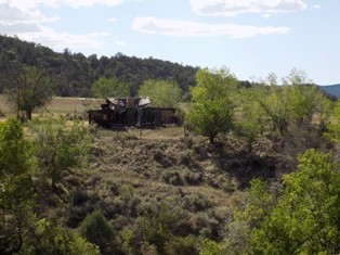
On a warm day in the mid-1950s, brothers Bob and Richard Flock were hiking on Blue Mesa, perhaps searching for arrow heads. The Flock boys no doubt knew that Blue Mesa, the current location of Animas Air Park south of Durango, Colorado, was known for its Ancestral Puebloan archeological sites. What they probably didn’t know was that Blue Mesa was on the route of Spanish expeditions like that of Domínguez and Escalante and later, the Old Spanish Trail.
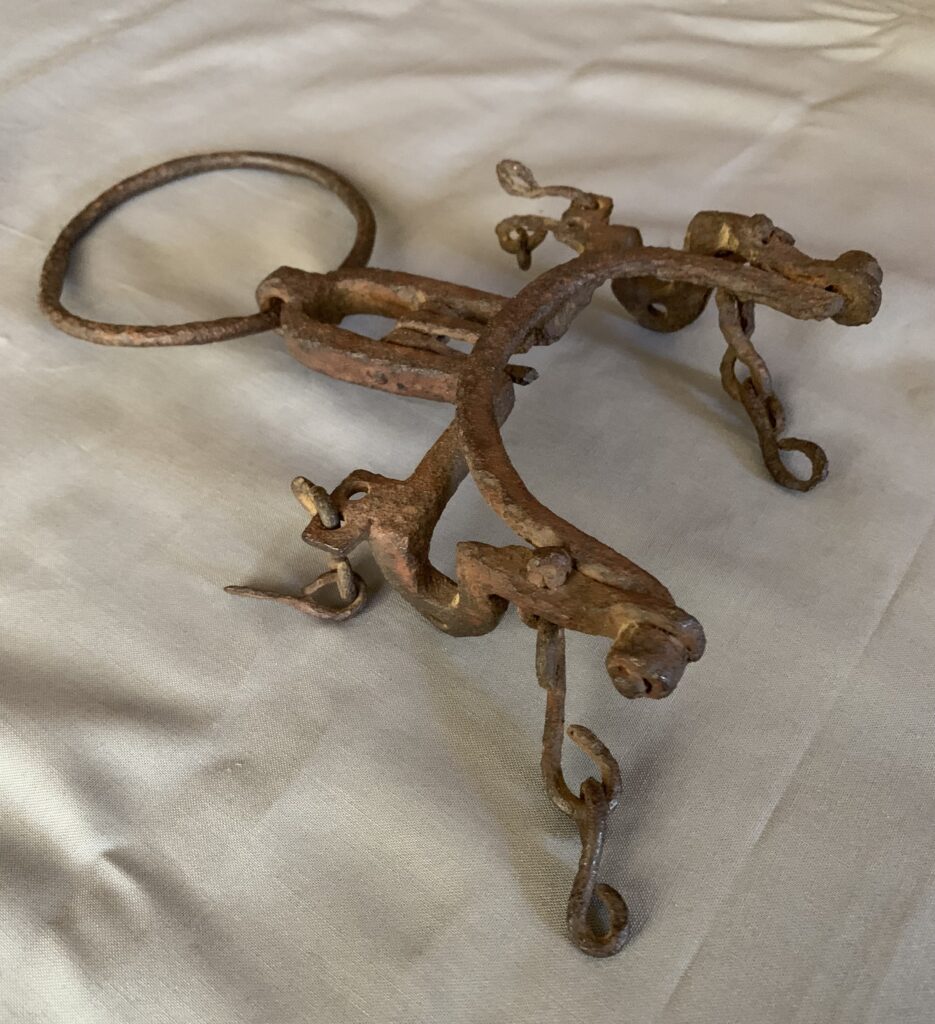
As they walked through the sagebrush, one of the boys found an interesting metal object half-exposed in the dirt. It turned out to be an old, rusted ring bit, the type of bridle bit popular in the Southwest during the Spanish Colonial and Mexican periods. Upon close examination, however, the bit isn’t a Spanish style bit. It has the distinctive features of one made by a Navajo.
A Navajo bit? Southwest Colorado was Ute territory, and the Utes and Navajos were traditional enemies. A Navajo horseman might have risked injury, capture or death traveling through Ute lands in the 19 th century. While the Navajos generally stayed south of the San Juan River (the unofficial boundary between the Utes and Navajos), they occasionally made forays into Ute territory to gather medicinal plants or to trade.
Spanish ring bits had their roots in the Moorish invasion of Spain in the 8th century, and the Spanish brought them to the Southwest beginning in the 16th century. The Navajos eventually obtained Spanish ring bits, but the Navajos didn’t learn the art of blacksmithing until the 1830s when Mexican blacksmiths were first hired to teach them. In those years, both metal and blacksmithing tools were scarce in the Southwest, even in the New Mexico settlements, and since the Navajos were semi-nomadic, their lifestyle wasn’t conducive to developing and maintaining blacksmith facilities with forges and tools.
When the Navajos returned to their homeland after incarceration at Bosque Redondo from 1864-68, iron and silver metal smithing began to flourish. One scholar noted that Navajo ring bits are “By far the most complex and interesting object[s] known to have been produced by Navajo blacksmiths.” Closely related to Mexican ring bits, Navajo bits demonstrate a few distinctive characteristics. These include a “C” shaped curve in the cheek pieces (Spanish and Mexican bits feature more open, flowing curves), chin bars that almost invariably swing (chin bars in Hispanic ring bits are usually fixed), and distinctive notches, or “set downs,” in the curved part of the cheek pieces.
While Navajo blacksmiths made many of these bits, it’s believed that Hispanic smiths in Santa Fe and elsewhere made Navajo-style ring bits for trade, especially the more refined ones.
The Navajo ring bit found by the Flock brothers is relatively simple in form and was likely made by a Navajo smith. It is missing some parts, notably the slack chains and rein chains, and the chin bar and other moving parts are rusted in place.
Many questions come to mind regarding this improbable find. How, why and when was it lost? Did a Navajo, Ute or other horse person lose it? Was it attached to a Navajo headstall, possibly decorated with silver?
Since the bit exhibits the fully developed traits distinctive of Navajo ring bits, it likely dates to the 1870-1890 period, more than 20 years after the close of the Old Spanish Trail. While a Navajo traveling in Southern Ute territory may have lost the bit, it seems more plausible that a Ute had acquired it in trade or obtained it as booty in a raid or skirmish.
This idea is bolstered by the fact that an important Ute trail, a route between the area occupied by the Southern Ute bands (Moache and Capote) and the Weeminuche band (later the Ute Mountain Utes), traversed Blue Mesa. It was a trail, in fact, that had originally been established by Ancestral Puebloans and possibly earlier Native American groups.
A route followed by Puebloans, Utes, Navajos, Spanish and Mexican traders – in important ways, this trail represents a crossroads of cultures. While it’s thought provoking to speculate about an old, rusted relic, the intriguing story behind this ancient Navajo ring bit will always remain a mystery.


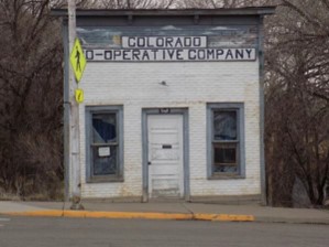
The Colorado Co-Operative Company and Ditch

The Colorado Co-Operative Company was created February 16, 1894. Its “purpose was to establish a co-operative community … where equality and service… should be the basis of the community.” In the summer of 1894, they sent B. L. Smith to find a location that would meet this purpose. He did, when he found 30,000 acres of sagebrush parks on the Tabeguache that could be potentially watered by way of a 17-mile-long ditch sourced from upstream of the San Miguel River. In November 1894, families began to arrive and settle in the first camp which is near present day Naturita. In the fall of 1895, the ditch was surveyed, roads were built, a sawmill set up and a settlement camp was added.

In February of 1896, there was ground breaking for the ditch. In September 1896, the ditch was completed to a point 1 ½ miles above Cottonwood Creek. In June 1898, the first head gate uprights were raised. Half the work had been completed. Two men had been killed by an explosion at the sawmill. June 4, 1904, ten years after the first survey, water flowed through the ditch to the initial point on Tabeguache Park. The ditch is still in use today.
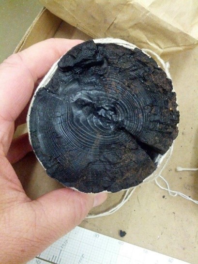

Pinon
In 1896, the town of Pinon, a permanent settlement, was established on Cottonwood Creek, where it meets the San Miguel River. It had its own post office, boarding house and school plus 50 other buildings.


Today little remains of Pinon, except a few old buildings and a tiny cemetery.
It is thought that the Domínguez-Escalante Expedition of 1776 would have passed near here on August 23, 1776.
Rimrocker Historical Society Museum
The Rimrocker Historical Society Museum is located off of Highway 141 in
Naturita, Colorado. It covers the history of the west end of Montrose County, which includes Redvale to Dry Creek Basin to the Mesa County line and then to the
Utah border. It provides information about the history of Pinon and the CCC Ditch,
Uravan and the Hanging Flume. Their website: https://www.rimrocker.org/museum
The following information is provided by the Rimrocker Historical Society Museum Unaweep Tabeguache Scenic and Historic Byway
Along Highway 141 at Mileage post 81.5 is a wide pull off with interpretive signage that tells the story of the Hanging Flume. The flume was to bring water to wash gold from gravel beds along the Dolores River. The total length of the ditch and flume is 13 miles long and the flume is bolted to the cliff below the road. It is definitely a place to stop and explore. It is listed by the World Monument Fund as one of the “100 most endangered Sites in the World”. It is an important site on the Unaweep Tabeguache Scenic and Historic Byway as well. For more information check out: www.utbywayco.com
At mileage post 76 is a small pullout with an interpretive sign. It is the story of
Uravan. In 1914 Standard Chemical built a mill to process carnotite ore which was mined in the area. By 1918 the company was producing 47% of the country’s entire domestic radium production. In 1928 U S Vanadium bought the property and build the town of Uravan. There were 1,500 people in town and 4,000 workers in the total operation. In the 1940’s uranium was milled for the Manhattan Project. Following WWII, the uranium was processed for peaceful purposes. In 1984 the uranium industry shut down and in 1986 the town was dismantled and buried.

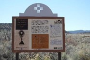
Mileage post 62.3 is the location of the marker that commemorates the 1776 Expedition of Domínguez and Escalante. They were hoping to discover a route from
Santa Fe to the missions in California. All though they did not make it to California, the notes of their expedition provided information for future exploration. They camped near here on August 21, 1776.
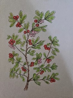
The Domínguez-Escalante Expedition entered Colorado from New Mexico on August 5, 1776. At the end of their Journal’s entry for that day, they list the plants they see along the San Juan River. “On either edge of the river there are leafy and extremely dense thickets of white popular, scruboak, chokecherry. manzanita, lemita, and gooseberry.” In the August 2nd Journal’s entry footnotes state that there is no English translation for “manzanita” and that “lemita” is also called Squawbush.
The August 2nd Journal entry reads “There are also clumps of lemita, which is a red bead the size of the Blackthorn’s, and its coolness and taste very similar to the lemon’s, so that in this country it is regarded as its substitute for making cool drinks.”

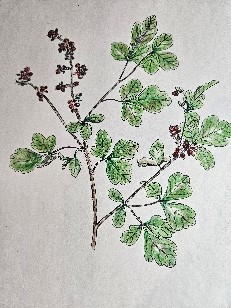
This plant has various common names including skunbush, sumac and sourberry. It grows from two to six feet tall on dry hillsides, in canyons, plains, deserts and valleys. The flowers are tiny yellow in summer and will develop into edible but very sour bunches of small sticky red berries with a flavor similar to lemon. The Native Americans dried the berries to make pemmican and used the stripped bark for basketmaking. The berries were also used as a lemonade-like beverage.
The entry for August 2nd goes on “… and another tiny fruit here called manzanita, the bush of which is like the lemita’s but the leaf more like that of celery. The little fruit’s size is almost that of ordinary chickpeas, the color is white in some and black in others, the taste a sharp bittersweet but agreeable. “
On August 24th the Journal entry reads that the Utes traded “raisins of black manzanita” with the Franciscans.

The evergreen shrub grows on rocky and bare ground throughout the southwest. The bark is reddish brown and can grow eight to ten inches and forms mats. The berries were a food source for Native Americans and wildlife and remained on the branches through winter. The plant was medicinal and also used as a smoking tobacco. The leaves were used for kidney and bladder problems and is still used today as a medicinal herb.
The three plants mentioned most in the Journal are: the scruboak, sagebrush and prickly pear. Often in the Journal entries, they describe how difficult these plants make their travels. The one most often mentioned in the Journal is the scruboak which is found in the Journal entries on August 5th , 9th , 25th , 30th , 31st and September 1st , 3rd , 5th and 8th.

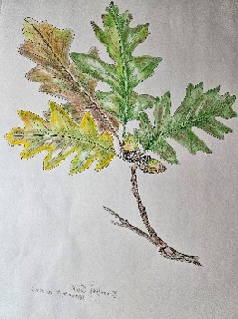
This deciduous tree is found from 4,000 to 8,500 feet usually on dry hillsides, slopes, canyons and mesas. It can grow to fifty feet tall and provide shelter, food and the wood provided firewood. It was grazed upon by both wildlife and livestock. Acorns were used as a food source, leached in water to remove the tonic acid and ground into a meal for a use as porridge. Native Americans may have used the tannins as dyes or astringents for sore throats.
The sagebrush was mentioned in the Journal on August 12th , 14th , 20th , 21st , 30th , and September 4th , 5th , and 10th . On August 12th they wrote “two and half leagues (6 ½ about miles) sagebrush stretch of poor pasture. On August 14th they wrote “for five leagues (13 miles) over a rather troublesome stretch of sagebrush”.

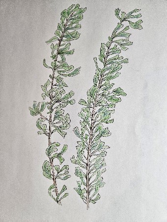
The sagebrush is extremely abundant in all of the southwest and grows between two and seven feet tall. Its habitat is the high deserts or plains and has silvery green hairy leaves, which are wedge shaped and highly aromatic. Of its highly fragrant appeal sagebrush was dried, bundled and used to make smudge sticks for ceremonies and used like incense. The smoke from the lit bundle was a means to purify oneself before sacred ceremonies. Sagebrush was used medicinally and also as campfire fuel. Cattle and sheep are able to browse on sagebrush as a food source when feed is scarce.
The prickly pear is only mentioned three times while the Expedition is in Colorado. Those entries were on August 20th and 30th plus September 6th. On both August 20th and September 30th they write there were a lot of small prickly pear cactus. On September 6th they write “two more leagues (5.2 miles) westward over broken terrain with some stone and a lot of small prickly pear cactus.”
Although the prickly pear is only mentioned three times while they are in Colorado, it is a plant that is very easy to recognize. If someone has ever brushed against or stepped on one, they would always remember it.

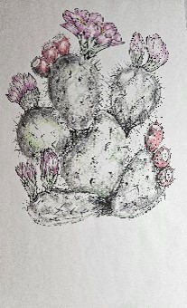
There are many species of prickly pear cactus commonly found throughout the
southwest in deserts, dry mountain slopes and grass-lands. The spread out flat, spiny pads are typically two to three inches wide and four to twelve inches tall and the blooms can be any color but mostly reddish to yellow. The succulent fruits, blossoms and pads are edible and served as a food staple to Native Americans.
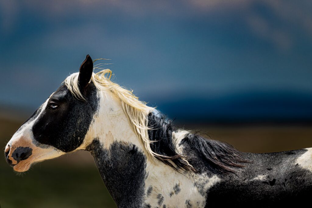
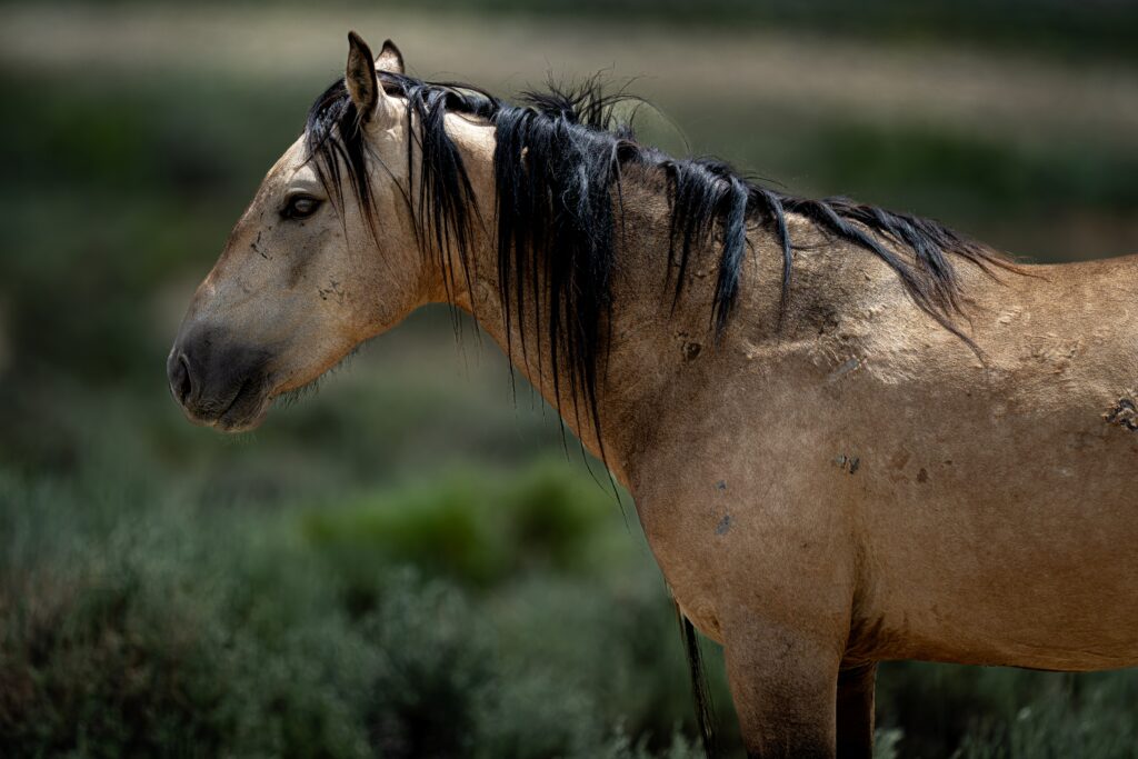
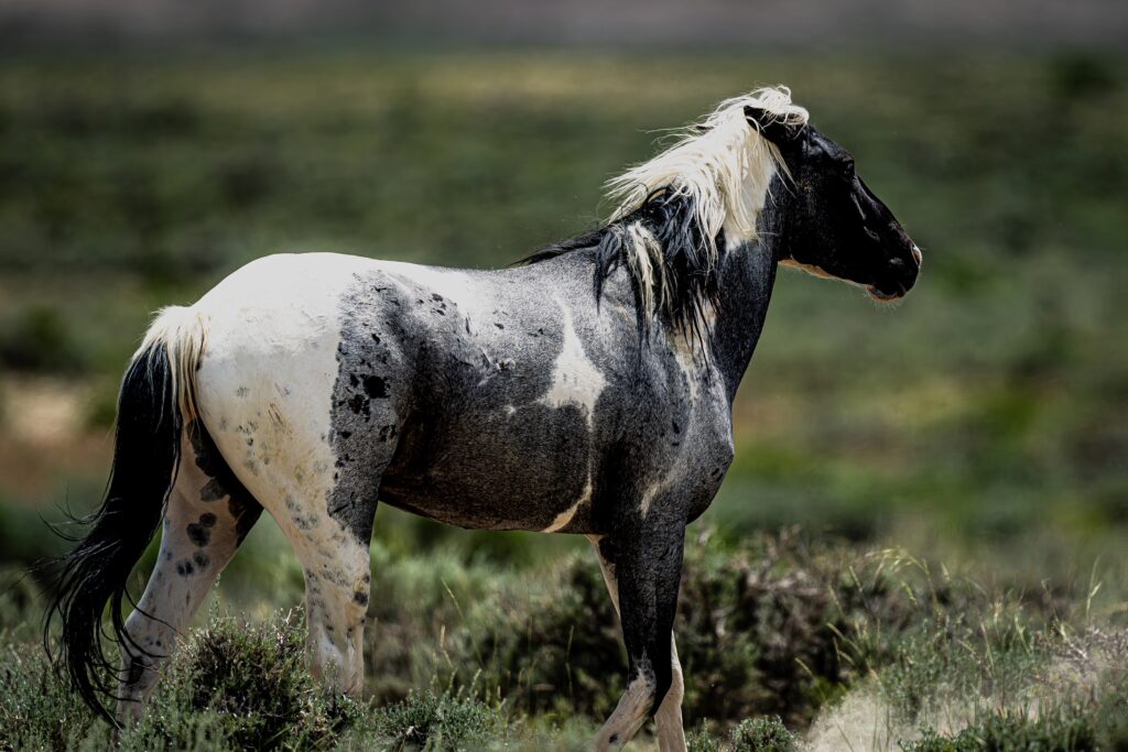
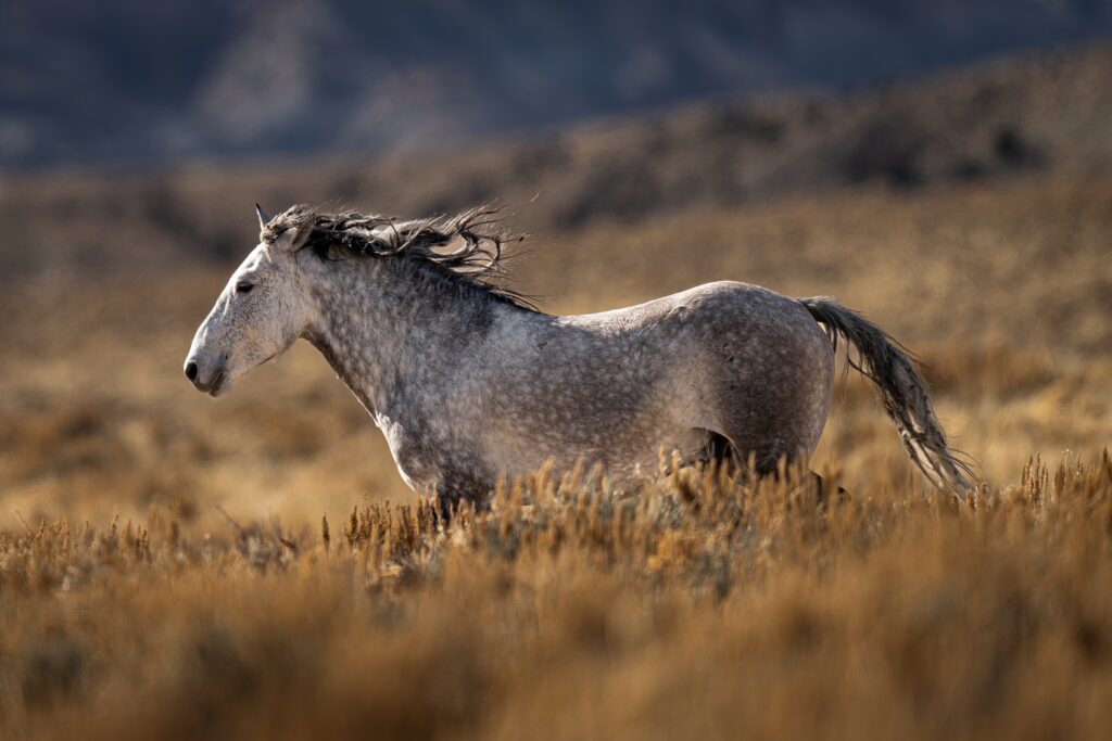
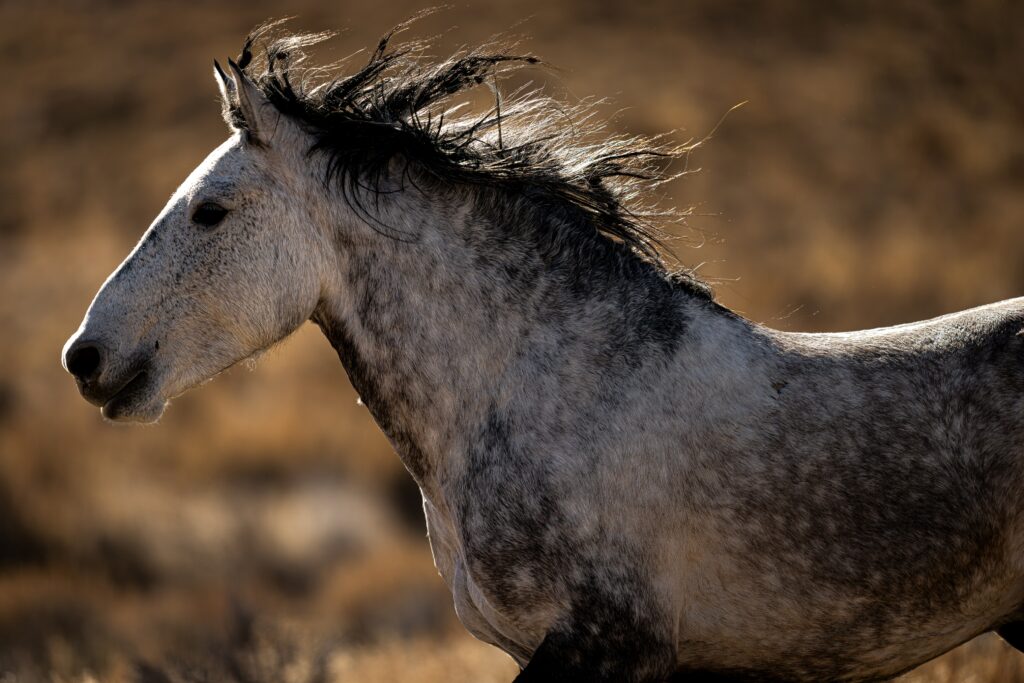
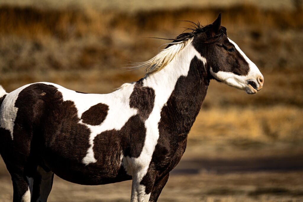
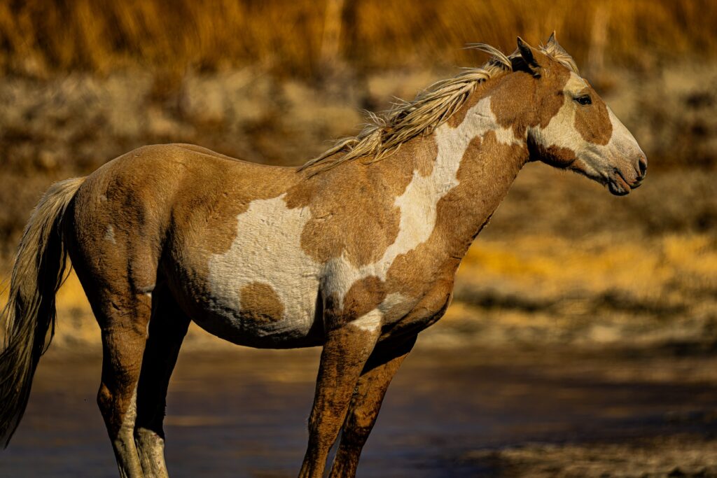
Sand Wash Basin is home to an iconic herd of wild horses which is located northwest of Maybell, Colorado. They are descendants from horses the
Spanish explorers them out brought with them out west when exploring and first settling our county. Some of the characteristics of these horses include a slightly convex nose and forehead and thick muscular necks.
The following are excerpts taken for a Colorado State University fact sheet
titled: “The History of Wild Horses & Burros in Colorado and the American West”
In 1519, the Spanish conquistador Hernando Cortés brought horses from
Cubanascnan (Cuba) to Tenochtitlán (Mexico City) as part of his conquering force to the mainland. Donkeys, called burros in Spanish, served subsequent conquering forces as pack animals and provide breeding stock for mules, a hardy hybrid of the horse and donkey. As Spanish conquest expanded throughout the western hemisphere, so did equine 4Kelenka, The Horse in Human History, 29-44..
Spanish horses and burros populated the western half of North America in the seventeenth century as Spanish conquistadores made their way north from Tenochtitlán into the arid reaches of the North American deserts.
American settlers came to call the horses running wild in the region mustangs, derived from the Spanish term mesteño. Throughout their expansion, the Spanish conquerors captured and enslaved Indigenous peoples and taught them European equine traditions. Later European colonists from France, England, and elsewhere also brought horses to the colonies on the Atlantic, Gulf, and Pacific coasts, bringing similar traditions 5John J. Johnson, “The Introduction of the Horse into the Western Hemisphere,” The Hispanic American Historical Review 23, no. 4 (1943): 588-606; Clive Roots, Domestication (West Port, CT: Greenwood
Press, 2007), 178-181..
The slow trickle of Spanish horses into Indigenous hands accelerated. By the turn of the nineteenth century, Indigenous groups such as the Núuchiu (Ute), Diné (Navajo), Nʉmʉnʉʉ (Comanche), Niimíipuu (Nez Perce), Absaroka (Crow), Tsêhéstáno (Cheyenne), and Hinono’eiteen (Arapaho) had substantial herds 8Andrés Reséndez, The Other Slavery: The Uncovered Story of Indian Enslavement in America (Boston: Mariner Books, 2017), 175. The term “lifeway” refers to the integrated way Indigenous cultures experience social, economic, and spiritual aspects of life. See Winona LaDuke, “Minobimaatisiiwin: The Good Life,” Cultural Survival Quarterly 16, no. 4 (winter 1992): 69–71 and Winona LaDuke, All Our Relations: Native Struggles for Land and Life (Cambridge, Mass.: South End Press, 1994) 4, 132..
In the region that became Colorado, the Núuchiu (Ute), Tsêhéstáno (Cheyenne), and Hinono’eiteen (Arapaho) peoples rapidly integrated horses into their lifeways. The Núuchiu (Ute) were among the very first Indigenous peoples to acquire Spanish horses. The Núuchiu (Ute) may have captured Spanish horses as early as the 1580s, but in 1637 several captives in Santa Fe escaped and took several Spanish horses with them. Horses solidified Núuchiu (Ute) power on and control of the Colorado Plateau and central Rocky Mountains. The Núuchiu (Ute) carefully bred and trained their horses over centuries, developing a unique horse culture that included specialty tack and riding techniques that allowed warriors to hang from the side of their horses while running and use the animals’ bodies as shields. They also developed a tradition of horse racing and gambling similar to the
Thoroughbred racing seen later in the New England colonies. In the mid-nineteenth century, Núuchiu (Ute) horse races attracted crowds of gamblers, including many settlers 9Pekka Hämäläinen, “The Rise and Fall of Plains Indian Horse Cultures,” Journal of American History,
vol. 90, no. 3 (2003): 833-862..


Father Domínguez and Father Vélez de Escalante together kept detailed notes on their journey in 1776, but it is not known if either one ever actually wrote a diary himself. If they did, it hasn’t been found. The original manuscripts that all English translations have been based on are copies or copies of copies of the reports that were filed in various offices of New Spain and the Franciscan Order about the attempt to find a route from New Mexico to California.
The earliest known copy is dated January 3, 1777, a day after they arrived back in Santa Fe. It is in the handwriting of Fray José Palacio, who was the secretary for Father Domínguez. It seems to be hastily written and is hard to read in places, so translators have to compare it with other manuscripts to be sure of what is meant. There are at least ten copies located all over the world, from Seville to Mexico City. There are several in libraries in the United States, from the Smithsonian in Washington DC to the Bancroft Library at University of California, Berkeley. The earliest, and the one used for the translation by Fray Angélico Chávez is located at the Newberry Library in Chicago. Who knows, maybe one day some scholar rummaging around in the archives somewhere will unearth the original original!
The Circle of Life is a central theme of Nuu-cíu (Ute) life & it is captured visually
throughout Nuu-cíu Strong (4 th grade resource guide). The Ute people have a unique relationship with the land, plants, and all things living. The Circle of Life represents the unique relationship in its shape, colors, & reference to the number four, which represents ideas & qualities for the existence of life.
The People of the early Nuu-cíu (Ute) Tribes lived a life in harmony with nature,
each other, and all of life. The Circle of Life symbolizes all aspects of life. The Circle
represents the Circle of Life from birth to death of People, animals, all creatures, and
plants. The early Nuu-cíu (Ute) People understood this cycle. They saw its reflection in all things. This brought them great wisdom and comfort. The Eagle is the spiritual guide of the People and of all things. Traditionally, the Eagle appears in the middle of the Circle.
The Circle is divided into four sections. In the Circle of Life, each section represents a season: spring is red, summer is yellow, fall is white, and winter is black. The Circle of Life joins together the seasonal cycles and the life cycles. Spring represents infancy, a time of birth, of newness – the time of “Spring Moon, Bear Goes Out.” Summer is Youth. This is a time of curiosity, dancing, and singing. Fall represents Adulthood, the time of manhood and womanhood. This is the time of harvesting and of change – “When Trees Turn Yellow” and “Falling Leaf Time.” Winter begins for gaining wisdom and knowledge – of “Cold Weather Here.” Winter represents Old Age, a time to prepare for passing into the spirit world.
The Circle also symbolizes the annual journey of the People. In this journey, the
People moved from their winter camp to the mountains in the spring. They followed
trails known to each family group for generations. The People journeyed to each family group for generations. The People journeyed as the animals did. Following the snowmelt, they traveled up to their summer camps. In the fall, as the weather changed, the People began their journey back to their winter camps. Once again, they followed the animal migrations into lower elevations. They camped near streams, rivers, springs, and lakes. These regions provided winter shelter and warmth.
The early People carried with them an intricate knowledge of nature. They understood how to receive the rich and abundant gifts that the Earth, Sky, and spirit
provided. They also understood how to sustain these gifts. They took only what was needed. The People used the plants, animals, and the Earth wisely. They gave gifts in return. This knowledge was the People’s wealth.
The Circle of Life is the rich cultural and spiritual heritage of the Nuu-cíu (Ute).
This heritage is still alive in the life cycle and seasonal cycles of today. It still is alive
within the harmony of nature. It is reflected in acknowledgement and practice of
honoring and respecting all things, people, and relationships. The Circle design can be found on the back of traditionally made hand drums. These drums are important
ceremonial instruments for the People today.
The early heritage of the Nuu-cíu (Ute) is the true wealth of today’s People. This
heritage provides an eternal guide for their way of life. The early Nuu-cíu (Utes) have given great gifts of knowledge and wisdom to their descendants. These treasures are just as relevant today as they were for their Ancestors. The Circle of Life is a symbol that represents the Nuu-cíu (Ute) People’s rich, full and beautiful heritage.
First, a few comments about sources and historical research that helped guide my research. The best sources for historical research are considered to be primarydocuments. The primary documents for the Domínguez-Escalante Expedition of 1776 are Escalante’s journal and Miera’s maps.
The location of the original journal is unknown, but the Newberry manuscript copy
translated by Fray Angelico Chavez in The Domínguez-Escalante Journal edited by Ted J. Warner is thought to be the earliest copy made from the original. This 18 th century copy in the Spanish language of the new world is possibly the best source of the journal that describes the Expedition. The English translation edited by Warner is one step removed from the copy in Spanish and the Spanish copy is one step removed from the original. Each step presents the opportunity for potential errors to creep in.
Chavez addresses 18th century Spanish translated to 20th century English in the
following way: “While naturally having both Spanish and English dictionaries at my elbow, I mainly listened to Padre Escalante (and his companions) speaking as I read the text aloud to myself. This was not only as a Spaniard or a Mexican would, but also as a twelfth-generation Hispanic New Mexican with an ear for the language of the times and the locale would – and as one thoroughly conversant with ecclesiastical and Franciscan terminology along with the style in which those eighteenth-century friars expressed themselves. As for the style of English employed, it is the result of writing and publishing poetry and prose in the language for the past four decades.”
As for the Miera maps, the location of the original map from which the copies were
made, is also unknown. Each of the copies has differences and probably had different intents. John L. Kessell describes similarities and differences of the map copies in his book, Whither the Waters.
Miera measured latitudes in his map using a compass and astrolabe. There is no
mention of time pieces important for measuring the latitude using an astrolabe, so the measurements were certain to be inaccurate. Longitude was estimated.
Distances travelled were estimated from the time traveled on horseback. If anyone has ever ridden through sagebrush flats or through rough ground, or up and down steep terrain, you would know distances were a rough estimate. For August 12, I plotted the route using the directions and distances from Mancos camp to Dolores camp. The distance traveled in the Journal was 22 miles in straight line segments, but this placed the camp about 2 miles further than my best estimate of the camp location. This makes sense since the horses would not be travelling in straight line segments. So Miera’s maps are expected to show longer distances than the actual travel distances.
I asked Anna Riling several years ago to see if she could georeference the UC Berkely hand colored copy of the “Tree and Serpent” map of Miera to Google Earth. It was a big ask and the accuracy of Mier’s map was not good enough to do so. However, the map is a beautiful piece of art and offers a general sense of the route they took.
So, we and others before us were left with less than ideal secondary or later documents to work with in trying to reproduce the route of the DE Expedition through Colorado for DEEEP. The DEEEP effort is preceded by Herbert B. Bolton’s own effort documented in Pageant in the Wilderness (1950), Robert S. Russon’s, A Trail Guide to the Dominguez-Velez de Escalante Expedition 1776 (1973), and The Route of the Dominguez-Escalante Expedition 1776-77, edited by David Miller (1976). All of these lend additional insights into the route taken.
The DEEEP team has used their extensive personal knowledge, historical resources, visiting areas of the route, and various maps to map the route of the DE Expedition through Colorado. After reading the team comments and reasoning, I came away thinking that of all the attempts to recreate the route, this is the best one.
I prepared a Spreadsheet of the rivers, water sources, camps, river crossings and
comments as a resource to prepare the legends. The importance of water can not be overemphasized. Much of the route had plentiful water but portions illustrated that water was a constant concern. Comments in Blue highlight the times water was a concern or there was a lack of water.
The spreadsheet contains each river or water source mentioned in the Journal. I added Creeks that the DEEEP team members indicated the Expedition would have likely encountered but were not in the Journal. These Creeks are highlighted in Red. The modern names of the river or creeks are provided when possible.
River crossings could be dangerous, so I listed the crossings that were in the Journal. The river crossings in Colorado apparently caused no problems although the depth to the horses’ shoulders was mentioned. I took this to mean there was some concern because of the depth of the water.
All the rivers mentioned in the Journal have their source in Colorado. The rivers may
have flowed from Colorado into other states. Some rivers were named to provide a point of reference for how much water was flowing in the rivers encountered by the Expedition. For example, on August 12th the water flow in the Dolores River that the Expedition encountered was judged to be comparable to the Rio Grande River (El Río del Norte).
I added a few comments that I think were instructive and would be of interest to readers of the accounts. On September 11, there was a successful buffalo hunt that helped restore some of the provisions that were rapidly being depleted. Also, there was mention of a pack mule that answers an important question about how provisions for the Expedition were carried. Mules for packing, horses for riding.
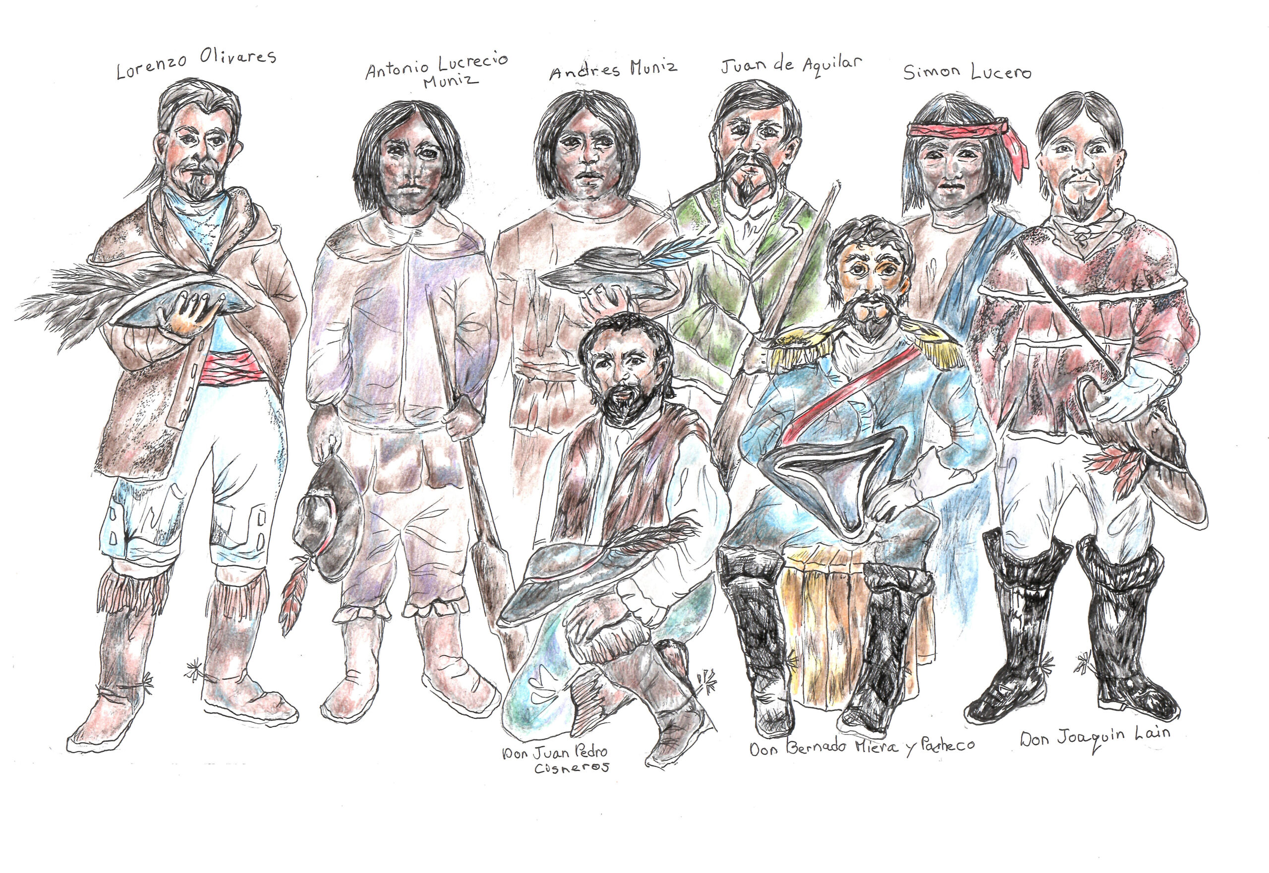
I was surprised that the DEEEP website did not have a map of the 1776 Expedition drawn by the cartographer don Bernardo de Miera y Pacheco included in the site. So, one of my meager contributions to DEEEP is the suggestion to include one of his maps. So I consulted with an expert, Professor Emeritus Dr. John Kessell. In our email and personal exchanges, he insisted that one map of the several in existence be included, and that is the Plano Geographico, de la tierra descubierta, nuevamente, Chihuahua,1778. Dr. Kessell also provided me a digital copy of the map from the British Library, London. When I gently requested that he write this introduction, his reply was, “As for a brief introduction to the 1778 map, please quote or paraphrase me in your words any way you wish. I’ve already said about all I can.”
Rather than me blathering on in my ignorance, here are my words in the way I wish: You can read about all Dr. Kessell has said about the maps in Whither the Waters published in 2017. This book is an excellent resource for Miera’s maps of the 1776 Expedition. His translation of the map’s title follows.
“Map of the territory newly discovered to the North, Northwest, and West of New Mexico drawn by me, don Bernardo de Miera y Pacheco, who entered upon its discovery in the company of the Reverend Fathers fray Francisco Atanasio Domínguez and fray Silvestre Vélez, as evidenced by the Diary and Log kept and submitted to His Majesty by the hand of his Viceroy with manuscript map. The present map he dedicates to the Lord don Teodoro de Croix of the Distinguished Teutonic Order, Commandant General in Chief of the Line and Provinces of this North America for His Majesty. Done at San Felipe el Real de Chihuahua, 1778.”
Yet, I can not help myself to say a few words as to why I think John insisted on this particular map. Go to the map, enlarge it to see the wonderful detail, and pretend you are following in the hoofprints of Miera and the two Padres. So, saddle up your Spanish steed and join the journey of the Domínguez-Escalante Expedition and with the expert eyes of Miera, see much of what they had seen.

Look for Santa Fe on the map, their starting point and Santa Clara where they spent their first night. The second and third nights they stayed at Abiquiu. The fifth night their first camp shown on the map (a cross on a circle) is on the Nutrias River. And you are off looking for the next camp as they travelled generally northwest. See the terrain, the rivers, the areas where different tribes lived and some of their dwellings, the names of the camps, mountains and rivers. Soon you will be in what is now Colorado on August 5,1776, at the El Belduque camp. Here is your starting point for the Colorado section of the Expedition. Enjoy your journey, take your time and look around and see what you can see.
Map citation: British Library, London, Add. Ms. 17.661.D*.
What did it mean that Frs. Domínguez and Escalante were Franciscans?
As Franciscans, Domínguez and Escalante were members of the Roman
Catholic religious community founded by Francis Bernardone (1181-1226) following his own religious conversion. Francis Bernardone is usually referred to as St. Francis of Assisi and his community is commonly called Franciscans, though officially named the Order of Friars Minor. As a young man, Francis Bernardone, had enjoyed the privileges of wealth as the son of a prosperous cloth merchant in the Italian town of Assisi, in the Province of Perugia and region of Umbria, approximately 120 miles northeast of Rome.
During the lifetime of Francis, control of Assisi was contested by an ancient, landed
nobility and a rising merchant class to which Francis’s father, Pietro Bernardone,
belonged. Against his father’s wishes, Francis renounced his wealth and social position upon his religious conversion following time spent as a prisoner of war in one of numerous small wars between Assisi and the neighboring city of Perugia. After his conversion, Francis attracted followers, and in 1209 took a simple “Rule of Life,” consisting of Biblical quotations to Rome, and surprisingly received verbal approval of his rule by Pope Innocent III. A more developed rule received written approval from Pope Honorius IV in 1223. The numbers following Francis exploded throughout his lifetime. Not long before his death in 1226, five thousand followers gathered in Assisi and then dispersed all over Europe to proclaim the Gospel. Beyond the vows of poverty, chastity, and obedience, which were normal parts of religious rules, Francis had added a provision for his followers to go among non-believers and proclaim the Gospel to them. This provision is the first time that a Roman Catholic religious community ever took on missionary evangelization as a specific and official part of its charism.
Franciscans were missionaries from the time of Francis himself, who had
traveled to Egypt in hopes of converting the Sultan al-Malik al-Kamil, but instead began a dialogue with Islamic religious leaders. Dialogue remains a hallmark of Franciscan mission efforts to this day. Francis wrote that missions could be conducted in two ways, first by living peaceably among non-believers and only after they have lived among them not engaging in arguments or disputes, but “subject to every human creature for God’s sake.” (Earlier Rule 12:6), then second, they are to announce the Word of God and seek the conversion of those to whom they proclaimed the Gospel.
Part of an incredible growth in religious life the 13 th century (the “Mendicant Renewal”) that included the founding of the Dominicans, Augustinians, Carmelites, and Poor Clares (founded by St. Clare of Assisi with the inspiration of Francis), Franciscan friars quickly dispersed throughout the universities of Europe including Bologna, Paris, Oxford, Prague, and Salamanca. They helped provide the energy for the entire scholastic intellectual movement of the later Middle Ages with scholars as John Duns Scotus, Bonaventure, Peter John Olivi, and Roger Bacon.
With this intellectual tradition behind them, Franciscans first went to the Western Hemisphere with Columbus on his second voyage in 1493. Ramon Llull, a member of the Secular Franciscans, as they are called today, had begun pushing for the study of languages for the purpose of evangelization in the 1390s. By the early
1400s, that was a standard Franciscan practice. So, when the friars reached central Mexico in the 1520s, Bernardino de Sahagún became one of the first anthropologists in the history of the world with his fifty years of study of the peoples of the region, their language and culture, all meticulously recorded in a work commonly referred to as the Florentine Codex.
Domínguez and Escalante would have seen themselves as “scouts,” recording what they saw and learned in hopes of other Franciscans following them. Their mission effort under these circumstances would have been to get there, see what was there, then get home and prepare for a more permanent Franciscan mission effort by themselves or by the others that they hoped would follow them. As they recorded what they were seeing, they would have participated as fully as possible in the work needed to keep the expedition going. As Franciscan friars, they were not bound to a rigorous “sit down and pray while others work” attitude. Franciscan friars often prayed what was called the “Brothers’ Office,” which meant that they could fulfill most of their obligations to pray by means of reciting memorized prayers through the day while they were doing other work that needed to be done.
Franciscans brought an incredible curiosity to all that they did along with their missionary zeal. In New Mexico between 1531 and 1776, the Franciscan friars studied the land and the Native peoples, as well as evangelizing. When Domínguez and Escalante departed Santa Fe on their expedition, they were following a path laid down by many Franciscans who had preceded them, even as they traveled to places where no Europeans had gone before.
For Further Information
Francis of Assisi: Early Documents, Volumes I, II, and III, edited and translated by Regis Armstrong, O.F.M.Cap., Wayne Hellmann, O.F.M.Conv., and William Short, O.F.M. (New York: New City Press, 1999 and 2002) Available to read and search in side-by-side original Latin and English translation at www:FranciscanTradition.org
Francis and His Brothers: A Popular History of the Franciscan Friars by Dominic
Monti, O.F.M. (Cincinnati: St. Anthony Messenger Press, 2009)
Bernardino de Sahagún, First Anthropologist by Miguel León-Portillo, translation by Mauricio J. Mixco (Norman, OK: University of Oklahoma Press, 2002)
The Franciscans by William J. Short, O.F.M. (Collegeville, MN: William Glazier/Liturgical Press 1989)
Franciscan History, The Three Orders of St. Francis of Assisi by Lorenzo Iriarte de Aspus, O.F.M.Cap. (Chicago: Franciscan Herald Press,1983)
November 3, 2021
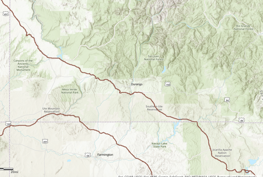
I am starting at Vado Lake, New Mexico as the route through the Jicarilla Apache
Reservation is critical to any discussion of the Old Spanish Trail (OST), or as the
old timers in New Mexico often call it, The Camino California.
The route leads north west out of El Vado Lake soon entering the Jicarilla Apache
Reservation. The OST transits the reservation for about 40 miles. That exceptionally interesting and scenic route is off limits to non Apache. For our ride I
attempted for several months to get permission to ride the route without success.
We had to bypass the reservation riding on adjacent Carson National Forest Lands.
At the San Juan River at Carracas the route is open along the river and on the
adjacent roadway, however, even though there is a bridge at Carracas, it leads
nowhere. The public road on the far side leading into the Carson National Forest is
gated and locked, hikers and horsemen and bicyclists can bypass it.
From Carracas to Arboles the route can be traveled by any means. The OST
transits miles of private and Southern Ute Reservation land. Using public roads,
the route can be driven, or bicycled or walked, but it is unsafe to ride a horse.
Aim for the intersection of Highway 550 and County Road 214. Travel down 214
to the Animas River. The OST, Rivera, Domínquez and Escalante all crossed
upstream from the bridge which joins with County Road 213.
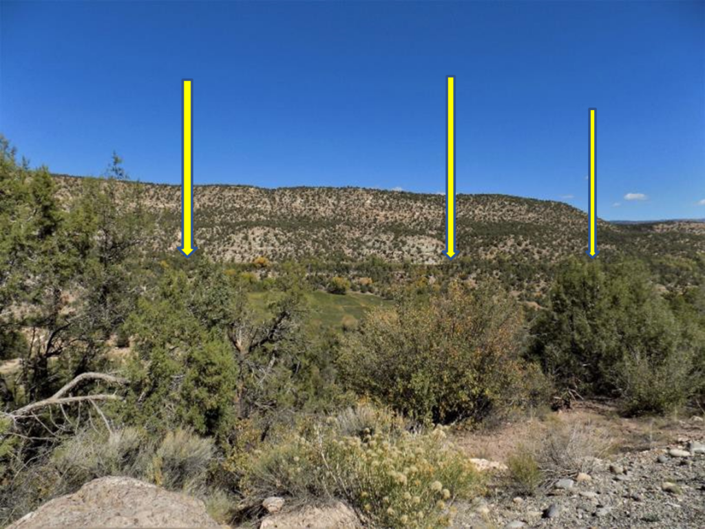
All the routes left the river and traveled up the valley now flooded by Lake
Nighthorse. When the Reservoir was created no attention at all was paid to the fact
that the Bureau of Reclamation was drowning a historically significant trail. To
this day there is no acknowledgement of the route, The Old Spanish Trail
Association and others are working to get signage and hopefully a trail along the
north shore.
You can bypass this area by taking CR 213 to CR 210. Travel 210, turn left onto
CR 141, then right on CR 125 to State Route 140. Turn right on this to Highway
160 at Hesperus. This is a high-speed highway, no place for a horse. It is pretty
much the OST route west to Mancos. At Mancos turn right onto Rt 184. Travel Rt
184 to the Intersection of US 491, turn right on it. Travel through Dove Creek. The
OST route lies to the west of the Highway through private land.

The OST bends northwest at the border angling off through the Great Sage Plain.