Lesson Plans
How to use DEEEP’s Lesson Plans
Overview
The lessons are designed so teachers can pick and choose which lessons work best with their schedule and needs. However, it is strongly recommended to do the Introduction Lesson before other lessons so students can have background on the expedition.
What do the different levels mean?
Each lesson has Level 1, Level 2, and Level 3. These include standards from grades 3-12 and are not divided by grade level in order for teachers to decide which level works best for their students. (If you have younger students that you feel could access the lesson content, feel free to use those lessons. Otherwise, we have a short K-2 option! This can be used for older students as well if you feel the level is appropriate.) Looking at the reading levels of the journal sections, the contents of the student response sheets, and specific lesson procedures can help educators decide which level is appropriate for their students. Most geography lessons have a “Version 2” option.
What does this mean?
While we would love for teachers to explore the entire expedition in Colorado, we also recognize that there is limited time in classrooms and teachers may only be able to choose one (or a few) geography lessons to complete. “Version 2” therefore is for teachers who have already done a geography lesson – it tries to reduce any repetitive features of the lesson and also brings in comparisons to previous lessons. Lesson 1 does not have a “Version 2” because it is assumed that, even if picking and choosing, teachers would do the sections in order.
Which lessons require the tactile blocks?
The tactile blocks are intended to be used in the geography lessons. HOWEVER, you can decide to simply use the terrain block photograph keys if the blocks are too logistically difficult. Teachers can also still complete significant parts of the geography lessons without tactile blocks if desired. This still achieves most learning outcomes – teachers will just skip anything that uses
the blocks. You can also decide to modify this by printing map images instead.
Lesson Descriptions
This can help you decide which lessons to choose:
● Introduction Lesson: Provides background on Colorado in 1776, the Spanish empire, and the Domínguez-Escalante Expedition. Again, recommended before other lessons.
● Ute Lesson: While interactions with Utes are part of the geography lessons, the Ute specific lesson dives into specific descriptions and stories while having a particular emphasis on keeping the perspective of historical sources in mind.
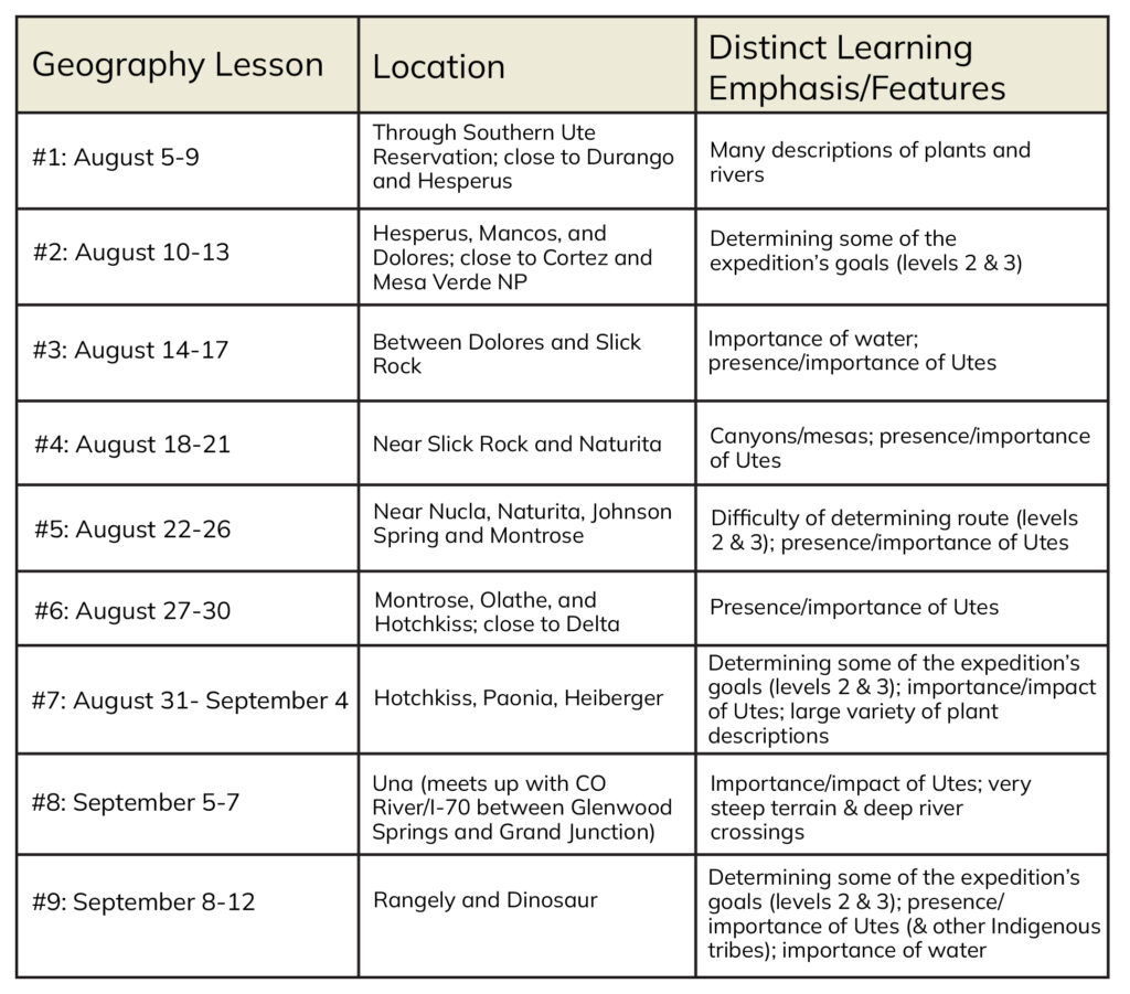
- Broken into 9 sections. Each section uses the Domínguez-Escalante journal entries to analyze the journey and geography along the way.
- All geography lesson plans address terrain/vegetation, challenges of geography, and why the expedition made certain decisions on their route.
- See above for use of tactile blocks.
- See above for “Version 2” option.
- Most of these lessons are very similar, but you can use the chart below to differentiate between them:


